Heckling Encouraged. Last night, while doing some last-minute shopping at Target in Chanhassen, a guy in an SUV slowed down in the parking lot, rolled down his window, and shouted out, "hey Paul, are you going to give my kids some snow for Christmas?" He wasn't smiling either. And he definitely wasn't pleased with my apologetic answer. "No". It's come to this. For the record, I'd love to see a few inches of snow for Christmas. I am not anti-snow. Nor do I have any control over the elements. I'm just a bewildered spectator, like everyone else. Please, we're just the messengers! If you see a beleagured Minnesota meteorologist on the streets, head hung low, do the unexpected and flash a smile, wave (with all your fingers). Make their day. I can assure you they're getting an earful from Minnesota snow-lovers.
8 hours, 46 minutes of daylight today. We'll pick up 3 additional minutes of daylight by December 31.
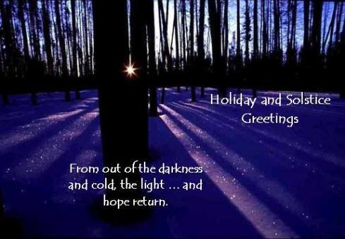
15 hours, 37 minutes of daylight on June 21, the Summer Solstice. Data courtesy of sunrisesunset.com.
- Henrik Ibsen (courtesy of the "Spo-Reflections" blog referenced below).
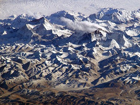
"In the last 30 years, glaciers in the Himalayas have shrunk by as much as 20 percent, according to the latest research." - from a story below from PRI, Public Radio International. Photo courtesy of NASA.

"Money's tight, Times are hard, So this will have to suffice, As my Christmas Card."
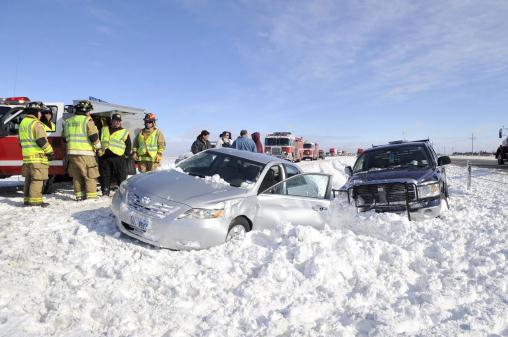
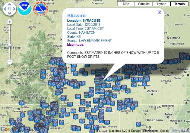
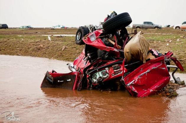
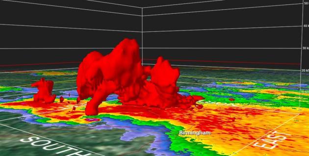
6 Deaths Blamed On Blizzard. More details from Reuters: "The storm filled roadside hotels and motels from eastern New Mexico to Kansas on Monday and triggered nearly 100 rescue calls from the Texas Panhandle. It was moving deeper into the Great Plains on Tuesday, according to the NWS. Four people died onMonday in a car wreck in New Mexico, said Mark Wiley, a meteorologist with the National Weather Service. And in eastern Colorado a prisoner and corrections officer were killed when the driver of a van transporting nine prisoners lost control on Interstate 70, authorities said."
Photo credit: "Emergency responders assists victims of a multiple-vehicle accident on westbound Interstate 40 about 15 miles west of Amarillo, Texas Tuesday, Dec. 20, 2011. Travelers in the Texas Panhandle were urged to stay off ice-packed roads Tuesday after up to 10 inches of snow covered parts of the region. (AP Photo/The Amarillo Globe News, Michael Schumacher)"
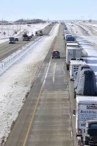
A Bright White Christmas In Amarillo (Texas). 3-5 foot drifts in Texas, while we stare out our windows at brown ground? What a strange weather pattern. "Westbound traffic is backed-up for miles on Interstate 40 west of Bushland, Texas while emergency crews remove vehicles involved in an accident that closed several lanes Tuesday, Dec. 20, 2011. Travelers in the Texas Panhandle were urged to stay off ice-packed roads Tuesday after up to 10 inches of snow covered parts of the region. (AP Photo/The Amarillo Globe News, Michael Schumacher)"
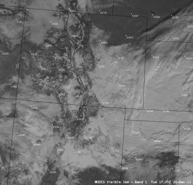
Distinguishing Snow From Clouds. This NASA "Modis" satellite loop shows a conventional visible image, followed by an enhanced "snow/ice" image. New snow shows up as red - and there is plenty of it!
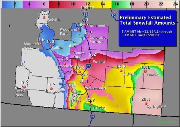
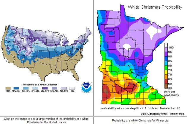
Who Will See A White Christmas? Much of the Rockies, the southern Plains (still leftover from the snow that fell Monday and Tuesday, and possibly parts of interior New England. Otherwise it's looking pretty brown east of the Rockies. Map courtesy of NOAA and WeatherCaster.
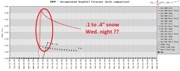
Snowy Coating Tonight? A weak, fast-moving clipper may drop a dusting or coating of snow on the Twin Cities tonight, but any snow that does fall will probably melt by Christmas Day. Sorry. I'll keep looking...
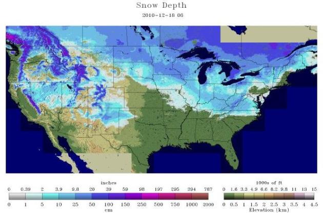
December 2010. Last year at this time roughly 48% of the lower 48 states were covered in snow, according to NOAA.
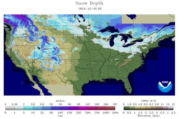
December 2011. I could be trite and cliche and say something stupid like "what a difference a year makes!" But I have more respect for you than that - so I won't say it. I'll only think it. Wow. At last report an estimated 26% of the lower 48 reported any snow on the ground.
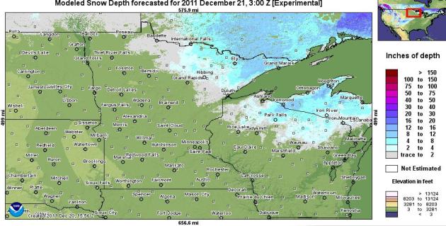
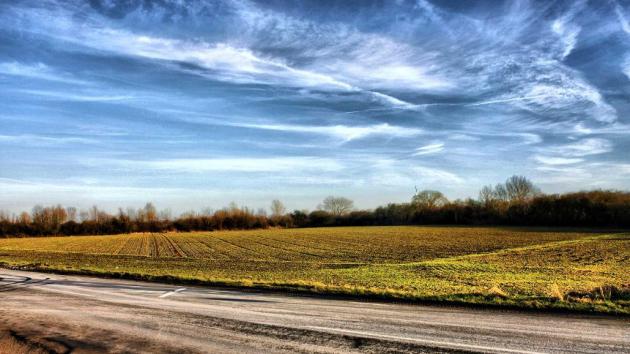
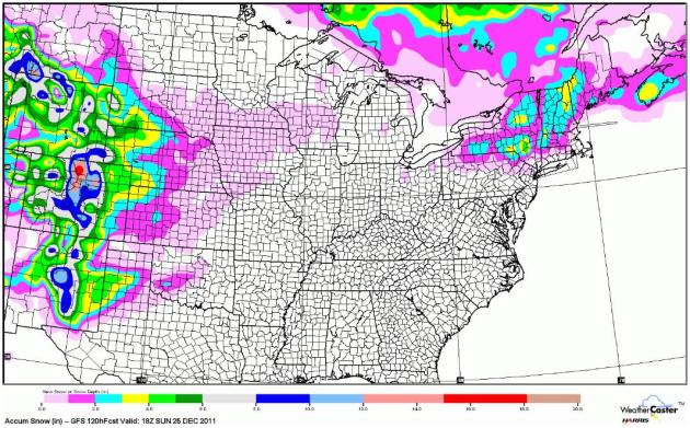
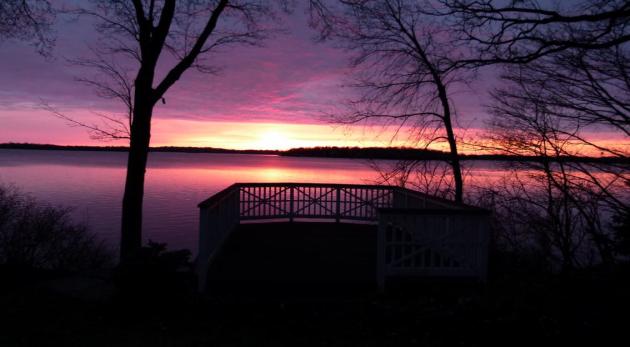
A Lighter Shade Of Brown. I can't remember a year we had so little snow on the ground for the Winter Solstice. Lake effect, coupled with a few clippers, has put down a 6-12" carpet of white along the North Shore and Boundary Waters, with snow on the ground across northern Wisconsin and the U.P. of Michigan. Other than that there is NO snow from the Dakotas across most of Minnesota and central/southern Wisconsin. Map courtesy of NOAA's NOHRSC interactive snowfall map.
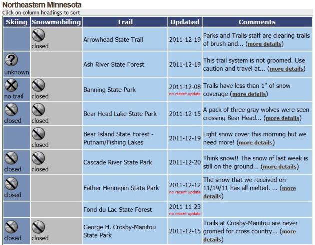
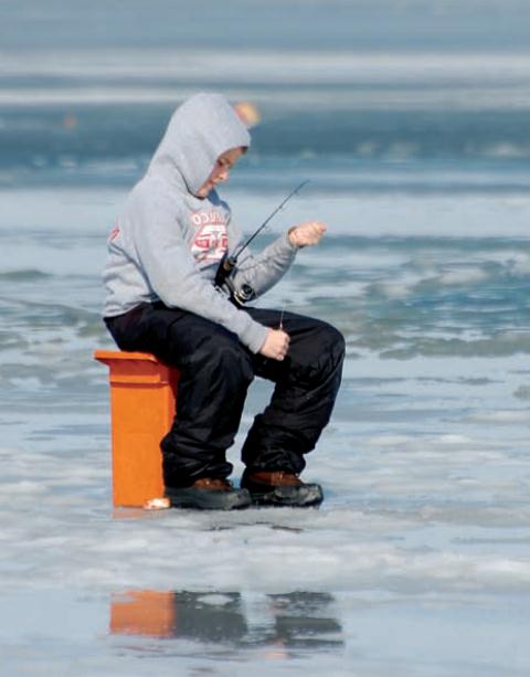
Tough Times For Snowmobilers And Cross Country Skiers. Hey, I feel your pain. I have a couple of (Polaris) sleds collecting dust in the garage. I want some serious snow, too. There is some snow (mainly over the Boundary Waters, where snowmobiling is frowned upon and punishable by death), but not nearly as much on the the other trails from Banning State Park to Cascade River State Park. Think snow! More details from the Minnesota DNR.
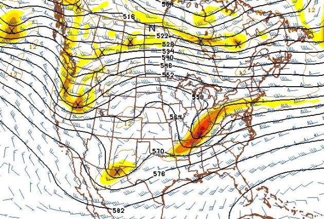
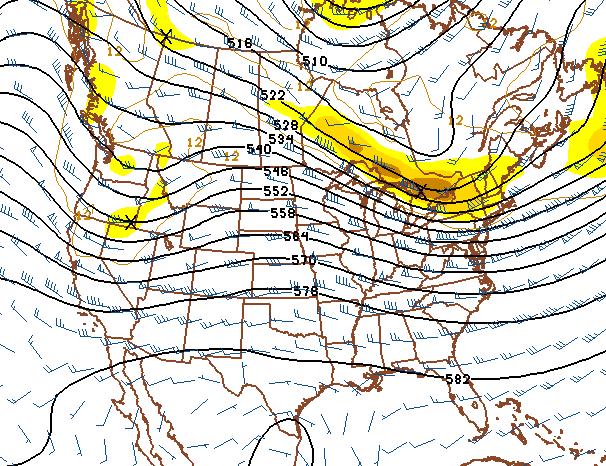
Christmas Day. The predicted 500 mb map (18,000 feet above the ground) for December 25 shows a deep trough of low pressure over the Ohio Valley, capable of a rain/snow mix from Chicago to Detroit and Buffalo. A ridge of high pressure over the Upper Midwest shold insure dry weather and sunshine, highs probably in the mid 30s.
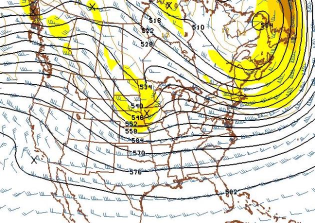
New Year's Day. The 500 mb (GFS) prediction for January 1 shows a trough of low pressure, a cold wrinkle aloft, pushing across the Dakotas into Minnesota, capable of a light accumulation of snow - but (once again) the system will move much too fast to tap any real moisture from the Gulf of Mexico, limiting just how much snow can fall. If this verifies it might imply an inch or so of slushy accumulation. No big deal.
January 5 - Still Waiting For Winter. This is pretty remarkable. The 500 mb prediction for January 5 continues to show a zonal, west to east wind flow aloft, guiding Pacific-modified air across the Rockies, resulting in temperatures 10-30 degrees above average for much of America east of the Rockies. I keep waiting for the "polar vortex" to break off from the Arctic Circle and dive south with subzero weather (we are long overdue). But I see no sign of any bitter air through the first week of January. What is impressive is the sheer persistence of this pattern. Winds aloft should be alternating from the southwest, west and northwest, but we've had a (dry/mild) westerly wind howling for much of the last 3-4 months, resulting in a deepening drought from Texas to Minnesota.
Going (Way) Out On A Limb. This winter reminds me of 2006-2007. We had a brown Christmas in 2006, with unusually strong winds blowing from the west, allowing Pacific air to penetrate unusually far inland. The January that followed was 6.5 F. warmer than average, with only 3 night below zero. By comparison we saw 7 subzero nights January of this year. We'll see, but I'm starting to think this will wind up being one of the milder, snow-free winters we've seen in the last 5-10 years.
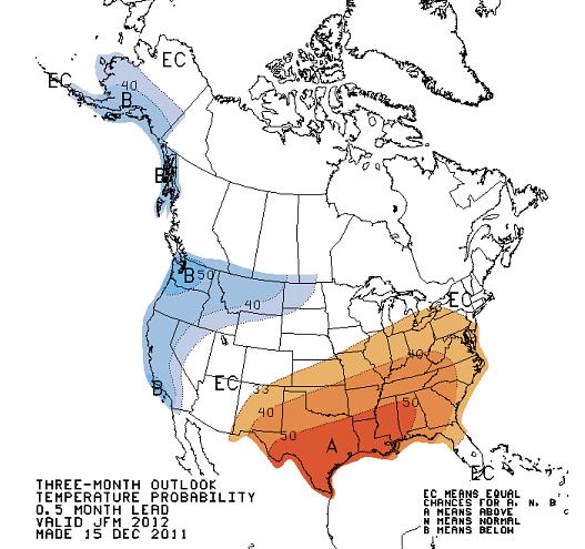
An Abbreviated Winter? It's still early to be making grand pronouncements, so I'll resist the urge to throw in the towel on the Winter of 2011-12. But the (revised) CPC, Climate Prediction Center forecast calls for warmer than average weather for much of the USA for January, February and March. Minnesota temperatures could go either way. But this is turning out to be an extraordinary La Nina - without the (strong) cold bias often seen over the northern tier states. I'm reminded of "persistence", which boils down to "don't buck the trends." Right now everything points to a continuation of unusually mild and dry into early, possibly mid January.
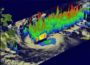
Tropical Storm Sendong: A "Calamity" For Philippines. Asian Scientist has a summary of the tropical storm that has resulted in nearly 1,000 fatalities across the southern Philippines: "AsianScientist (Dec. 20, 2011) – Under cover of darkness, a tropical storm named Sendong (also known as "Washi") arrived early last Saturday morning, bringing with it a tragedy that has cast a shadow on what was supposed to be a joyous Christmas time. We have reports that due to the amount and force of rainfall, even dump trucks turned over and were swallowed by mud. Families were borne away from the river and carried out to sea, where they were then rescued by the Coast Guard and the Navy. As of six this morning, nine hundred and 957 of our countrymen died because of Sendong. One thousand five hundred and eighty-two have been injured. We continue to look for the 49 that are still missing; our people have already rescued 432. According to NDRRMC’s latest figures, 63,079 families have been affected by this calamity."
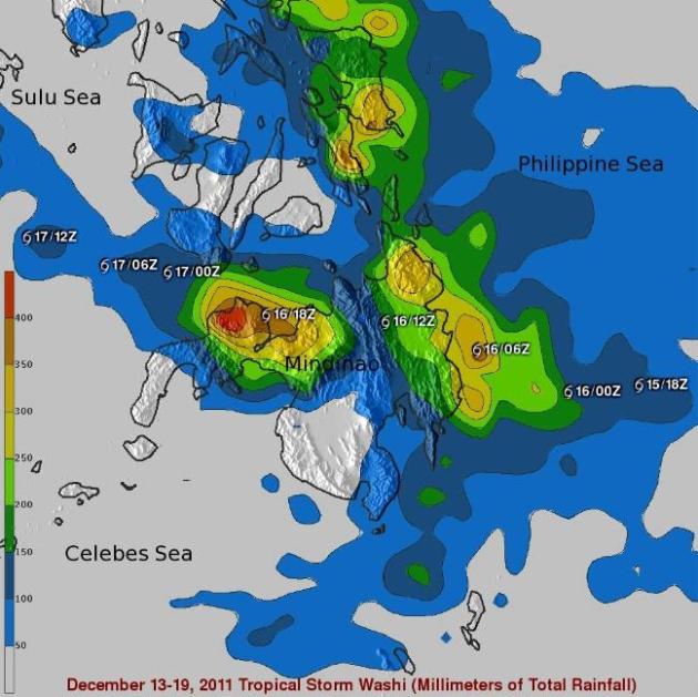
NASA's TRMM Satellite Measured Washi's Deadly Rainfall. 400 mm of rain is equivalent to nearly 16" of water falling on the north shore of Mindinao. Here's a press release from NASA: "NASA's Tropical Rainfall Measuring Mission (TRMM) satellite was providing forecasters with the rate in which rainfall was occurring in Tropical Storm Washi over the last week, and now TRMM data has been compiled to show rainfall totals over the devastated Philippines. Washi, known locally in the Philippines as Sendong, began as a tropical depression on December 13, 2011 in the West Pacific Ocean about 2150 km (~1333 miles) due east of the southern Philippines. Washi only intensified slightly and never exceeded tropical storm intensity as it tracked due west towards the southern Philippines' island of Mindanao."
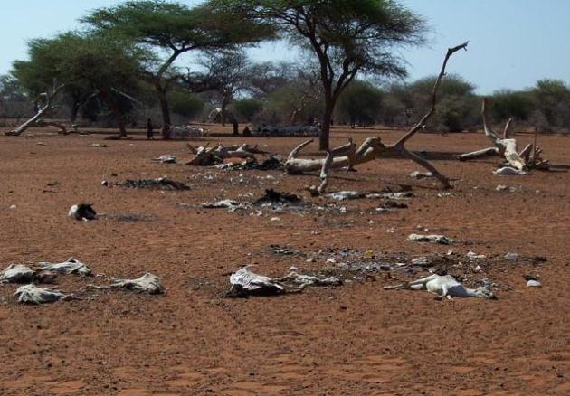
Deadliest Weather Disaster Of 2011: East African Drought. Dr. Jeff Masters at Weather Underground examines a slow, silent killer, one that didn't make the news as much as it should have this year: "The deadliest storm of 2011 is Tropical Storm Washi, which is now being blamed for 957 deaths in the Philippines. Washi's heavy rains triggered devastating flash flooding on the island of Mindanao last Friday. However, the deadliest weather disaster of 2011 is a quiet one that has gotten few headlines--the East African drought in Somalia, Kenya, and Ethiopia. On July 20, the United Nations officially declared famine in two regions of southern Somalia, the first time a famine has been declared by the UN in nearly thirty years. Almost 30,000 children under the age of five were believed to have died of malnutrition in Somalia this summer, and the total death toll of this great drought is doubtless much higher." Photo above: USGS.
No. 1 Texas
Texas was hit by eight of the nation's billion dollar disasters -- the most of any state in the country. Of the eight, the three most devastating were drought, heat, and wildfires. The drought still grips the state, and it is the most intense one-year drought on record. Unlike past dry periods, the damage to the state has been aggravated by record-breaking heat. Groundwater levels in much of the state have fallen to their lowest levels in more than 60 years, according to observations from NASA satellites.
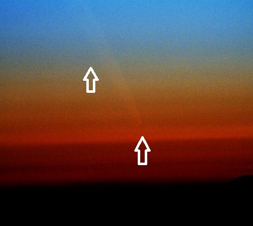
UPDATE: This morning in New Zealand, Minoru Yoneto photographed the ghostly tail of Comet Lovejoy shining through the twilight (above).

Outlook: Increasingly Fickle Winters
Welcome to the shortest day of the year. In truth, it's a tie: every day from December 20-25 has 8 hours and 46 minutes of daylight. But today is, in fact, the worst day of the year to get a tan (or burn) in the Northern Hemisphere; the sun as low in the southern sky as it ever gets. We'll pick up a minute of daylight by next Tuesday, 3 minutes by December 31. It's all uphill from here in the sunlight department. I don't know about you, but December 21 marks a sort of psychological turning point for yours truly. We've bottomed out in the sunshine department, and (amazingly) the coldest air of the season is, on average, about 3-4 weeks away. So far it's been the definition of an easy winter. Will this last? We'll see snow, and it will get cold, but there's little doubt that this winter will be radically different than last winter, continuing a trend of mostly-wimpy winters since about 1998. Don't write winter off just yet, but I think you can exhale...just a little.
Remember when it snowed in October, and snow would stay on the ground through March? Back in the 1970s Minnesota experienced "real winters". Since then snow has been a gamble; some winters we get socked, but the majority of winters are, well, like this. Recent research suggests snow cover across the Northern Hemisphere has decreased by approximately 8 percent since the 1980s, which scientists attribute to warming temperatures. Since the 1970’s December-February temperature increases have ranged from 1 to 2 degrees Fahrenheit in the Pacific Northwest to about 4 degrees F. in the Northeast to more than 6 degrees F. in Alaska. Winters are getting shorter, too. Spring arrives 10-14 days earlier than it did just 20 years ago. In addition, the date that rivers and lakes freeze over is later, and spring-ice breakup is happening earlier.*
Many Minnesotans are just fine with our shrinking winters and lack of snow, but I worry about soil moisture, a deepening drought, and the tens of thousands of locals who make a living from snow (playing in in, plowing it, etc). A cool, dry week is on tap - good news for holiday travel. The mercury could make a run at 40 again on New Year's Day.
* Data from a January 2010 paper released by the National Wildlife Federation.
Climate Stories....
Oddball Winter Weather: Global Warming's Wake-Up Call For The Northern United States. Here's a fascinating paper (pdf) released from the National Wildlife Federation in January, 2010. Many of the topics highlighted in the paper are playing out this winter, in fact a majority of winters since 1998: "Global warming is having a seemingly peculiar effect on winter weather in the northern United States. Winter is becoming milder and shorter on average; spring arrives 10 to 14 days earlier than it did just 20 years ago. But most snowbelt areas are still experiencing extremely heavy snowstorms. Some places are even expected to have more heavy snowfall events as storm tracks shift northward and as reduced ice cover on the Great Lakes increases lake-effect snowfalls. Even as global warming slowly changes the character of winter, we will still experience significant year-to-year variability in snowfall and temperature because many different factors are at play. Milder winters disrupt ecosystems in some surprising ways. Bitter cold temperatures naturally limit the spread of pests, diseases, and invasive species. The absence of extreme winter cold across the mountainous West has enabled an explosion of mountain pine beetles and caused a massive die-off of pine forests. Some important plants—–for example, walnuts, peaches, and cherries—– require a certain exposure to cold in order to flourish. Plants and animals also can be caught unawares when milder conditions are punctuated by severe winter weather. Across the Great Plains and Southeast United States, a cold snap in early April 2007 caused more than $2 billion in crop losses after an unusually warm March led to premature crop growth. "
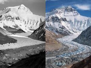
Himalayan Mountain Glaciers Show Signs Of Global Warming. PRI, Public Radio International, has the story: "As the global climate changes, one of the clearest manifestations of the change is in the disappearance or shrinking of the glaciers in the Himalayan mountain range. These glaciers provide fresh water to 40 percent of the Earth's population and their disappearance could be devastating. In the last 30 years, glaciers in the Himalayas have shrunk by as much as 20 percent, according to the latest research. The International Center for Integrated Mountain Development, based in Nepal, drew that conclusion after conducting what is believed to be the most comprehensive study ever of Himalayan ice melting. The findings concern David Breashears, a mountaineer, filmmaker, and executive director and founder of the non-profit Glacierworks."
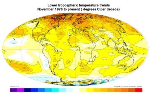
Satellite Climate Data At 33 Years: Questioning Shaky Claims That Downplay Global Warming. Meteorologist Andrew Freedman, from the Washington Post's Capital Weather Gang, has a post that sheds light on dubious claims about the reliability of satellite data and the ability to measure rising temperatures from space: "An interesting press release marking the 33rd anniversary of the satellite temperature record makes questionable claims dismissive of the human role in global warming. These claims are not supported by the scientific literature. The release, from the University of Alabama at Huntsville (UAH), reports that the warming trend in the lower atmosphere is lower than at the surface, and states that the satellite data points to flaws in climate models used to project how the planet’s climate system may respond to increasing amounts of greenhouse gases in the air."
Climate Change Createst Need For Better Extreme Weather Preparation, Experts Say. Insurancenewsnet.com has the release: "WASHINGTON, Dec. 19 -- The American Association for the Advancement of Science issued the following news release: It has been a record year for weather-related disasters in the United States, from historic drought in Texas to record-breaking floods in North Dakota, and the risk of such extreme events is likely to keep rising, experts said at a recent Capitol Hill briefing that AAAS helped organize. While it is impossible to say if climate change is responsible for a specific weather event, the experts said, it probably is increasing the intensity of some disasters such as the Texas drought. And whatever the causes, the financial losses from such events are increasing as more people live in vulnerable areas. Since the future is inherently uncertain, it is not particularly useful to debate whether a specific weather event is caused by climate change, said Jay Gulledge, senior scientist at the nonprofit Center for Climate and Energy Solutions (C2ES). What matters, he said, is whether there are statistical trends that are consistent with scientists' expectations of climate change. Such trends are happening for some types of extreme weather, Gulledge said."
What is sea ice and what is happening to it?
Climate Change Is Here. The Business Mirror has the story: "WHEN Tropical Storm Sendong swirled from the Pacific Ocean last weekend, it dumped in a matter of hours in northern Mindanao the equivalent of a month of rain. The resulting floods washed away entire villages, flattened homes made mostly of light materials, destroyed bridges of concrete and steel, and tossed vehicles every which way. When the water receded, the death toll from the flash floods had reached more than 700, with hundreds more missing. Latest reports show that the number of fatalities has reached 1,000, making Sendong among the destructive typhoons to hit the country. Climate change and global warming are here, no doubt about it. And the government should have in place comprehensive plans for identified disaster-prone areas, such as coastal and mountainside communities, to minimize loss of lives and destruction of property, public infrastructure and agricultural crops when disaster strikes."
State Should Brace For Greater Disasters, Rising Costs From Climate Change, Experts Say. California's North County Times reports: "California should prepare for massive storms, frequent and severe wildfires, and dwindling snowmelt, scientists at a climate conference at Scripps Institution of Oceanography said last week. The conference showcased new research on the practical consequences of a warming planet. Although similar events have often presented climate research, the conference last week highlighted the implications of warming on wildfires, water supply, energy policy and biological diversity. It's an approach that sidesteps political debate over climate change, and places it in the realm of resource management and emergency preparedness, following an initiative by Gov. Jerry Brown, said conference organizer Dan Cayan, a research meteorologist at the institution. "Climate change is polarizing, but when you talk about floods and fires, everyone agrees that they are huge problems," he said. "Most of this is phenomena we have seen historically. In the future, it looks like it will be amplified, both in terms of magnitude and frequency."