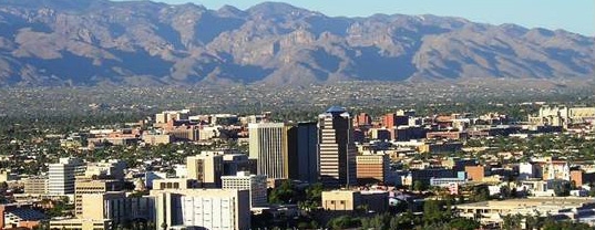
 Blast-Furnace Heat.
 Temperatures may top 100 later today across 8 states, from Arizona, New Mexico and Texas northward to Nebraska and the Black Hills of South Dakota.
 Fewer Severe Storms Today
. Fewer severe storms are expected today. Over 4" of rain may soak drought-plagued regions of south Florida, T-storms rumbling from the Outer Banks of North Carolina southward to the Gulf Coast. SPC has a slight risk of T-storms over Montana later today.
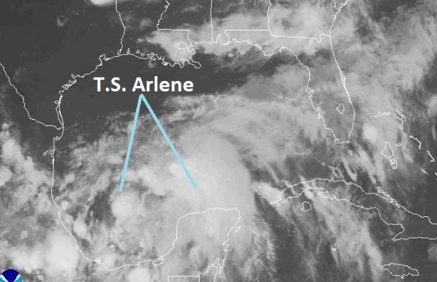 First Tropical Storm of 2011
. "Arlene" is a minimal tropical storm in the southwestern Gulf of Mexico - heading toward Mexico. Details below.
"...Scientists used to say, cautiously, that extreme weather events were "consistent" with the predictions of climate change. No more. "Now we can make the statement that particular events would not have happened the same way without global warming," says Kevin Trenberth, head of climate analysis at the National Center for Atmospheric Research (NCAR) in Boulder, Colo." - article on extreme weather and climate change in the U.K. Guardian (details below).
"...
It’s absurd that “climate change” has become an unpronounceable phrase under Obama and that green technology initiatives have been stymied by sterile ideological dispute. Intelligent use of resources makes strategic sense for America whatever your hang-up on global warming." - Roger Cohen in a N.Y. Times Op-Ed (details below).
"...
I'd like to see a politician with the courage and will to explain how America HAS to reinvent itself as a greener, more sustainable nation, and how the drive toward self-sufficiency can generate new jobs and new industries focused on weaning America off carbon-based fuels. Who will that be: Obama, Romney, Huntsman? Who is going to step up and lay out a blueprint for renewal and reinvention? Lay out a credible vision. Surprise us."
 Tropical Storm Arlene
. Packing a 40 mph punch, "Arlene" is the first tropical storm of 2011, heading due west, toward Mexico, where it may dump 10-15" rains in the coming days. Infrared satellite image courtesy of
NHC.
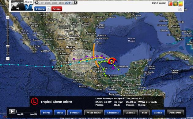 Bi-Coastal Tropical Cyclone?
 Arlene may pass across Mexico, weakening rapidly as it loses its moisture-source. There is a very small probability that the disturbance could re-intensify once it passes into the Pacific within 4 days. Graphic courtesy of NHC and Ham Weather.
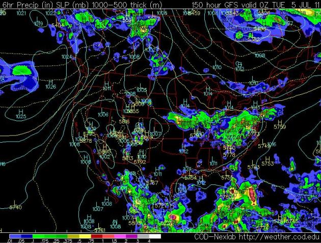 4th of July Preview.
 Here is the latest GFS
model, valid 7 pm Monday evening. I wouldn't put too much stock into this yet. In the coming days we'll be looking at trends, seeing if there is continuity between the various models. Right now models hint at a (weak) bubble of high pressure over Minnesota Monday, with a much better chance of heavy T-storms from eastern Nebraska to Iowa and Chicago. Odds favor mostly-dry weather for 4th of July festivities in Minnesota. It's early, much can change - hopefully for the better.
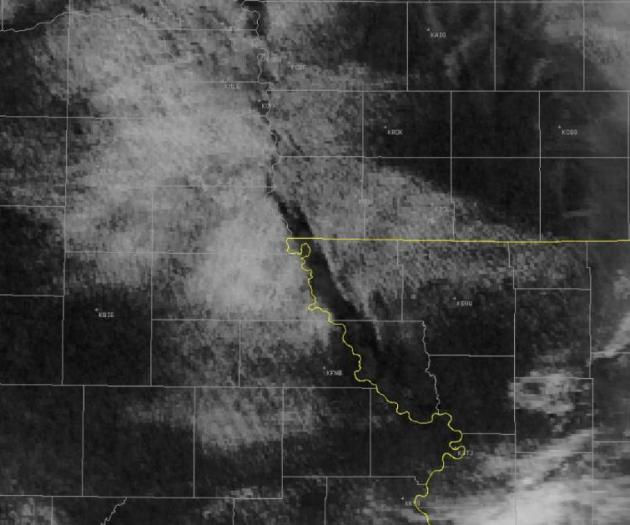
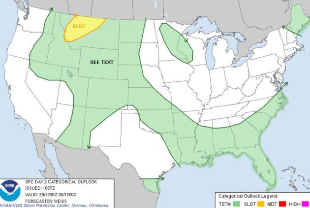 Wednesday Severe Risk
. It may not be quite as noisy today, more T-storms across the drought-plagued southern U.S. A few storms may turn severe across Montana, but SPC
doesn't expect as much hail or straight-line wind damage as previous days.
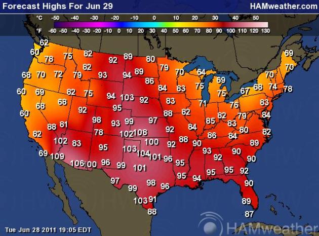 Wednesday: Expanding Heat
. 100-degree heat may spread as far north as the Black Hills of South Dakota today, at least 8 states expecting highs above 100 later today. Meanwhile cool 60s and 70s will provide a little free A/C from northern New England to the Great Lakes, unusually cool weather from the San Francisco Bay area northward to Seattle.
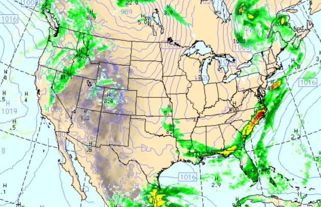 Wednesday Rainfall Potential
. The WRF/NAM
model keeps showers and heavy T-storms in the forecast from the Outer Banks of North Carolina southward to Miami, west to New Orleans. A weakening front will drag a few rain showers into Boise and Reno, pop-up instability T-storms from the Front Range of Colorado to Yellowstone Park. Much of the Plains, Upper Midwest and Great Lakes will be sunny and dry.
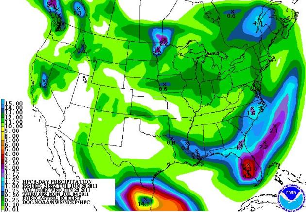 5-Day Rainfall
. NOAA's latest QPF printso ut over 4" of rain for south Florida, helping to relieve drought conditions south of Orlando. Heavy storms may drop 1-2" on the Red River Valley - as much as 14" predicted in the path of Tropical Storm Arlene, just south of Brownsville, Texas.
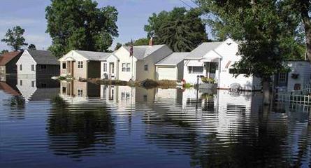
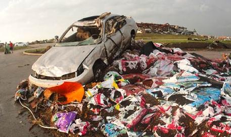
Pictures Of The Worst Flood In North Dakota History. The
Business Insider has some amazing photos that show the severity of recent floods in Minot and all across the state of North Dakota: "
North Dakota is suffering from its worst flood in history after the Souris River broke the levees last week in Minot. 11,000 residents have been evacuated and 1,100 National Guardsmen and Airmen from the local Air Force base have been monitoring dikes, controlling traffic, and maintaining security. Few of the 4,000 homes affected by the rising waters have flood insurance."
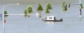
Long Road Home For Displaced North Dakota Residents. Again, it's almost surreal (from a meteorological perspective) that we're experiencing such widespread (river) flooding in late June. This would be more typical in March, April, maybe early May, but the shear extent and severity of the flooding is what is baffling for meteorologists. More from
Reuters: "
Dirty debris-laden Souris River floodwaters were slowly receding on Monday from Minot, North Dakota, where thousands of displaced residents may wait weeks before they can survey extensively damaged homes. The Souris River flooding smashed a 130-year-old record by nearly 4 feet, rolling over permanent and temporary flood protections five days ago and on Monday leaving traffic jammed on the only route connecting Minot's north and south sides. A drive that normally takes 15 minutes at most extended to two or three hours or more, said Dean Lenertz, a Minot Fire Department captain and city spokesman. The river by Monday had pulled back a half foot from the peak reached late Saturday to early Sunday at the Broadway Bridge but it could be weeks before some residents can get a look at the homes they were forced out of on Wednesday. "It is going to be a very slow process of drying out these wetted areas over the next probably two to three weeks," said Allen Schlag, a National Weather Service hydrologist based in Bismarck, North Dakota. About 12,000 residents have been displaced by the flooding, but city officials do not have an exact figure. A few hundred people have used Red Cross or other shelters and many have turned to friends, family and neighbors for temporary housing. "
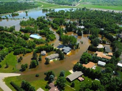
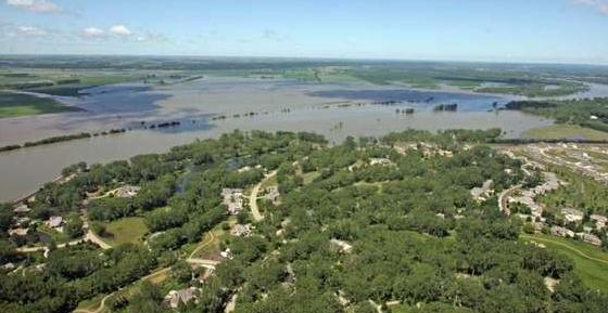
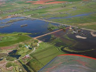
Missouri River Flooding - Telling The Story With Photos. The
Des Moines Register has a photo essay focused on historic flooding underway on the Missouri River; the extent (and duration) of flooding is remarkable - impacting the lives of hundreds of thousands of residents from the Dakotas southward to Missouri: "
Aerial and ground tour of flooding Monday June 27, 2011, along the Missouri River from Sioux City to Council Bluffs.(Rodney White/The Register)"
Information On Flood Flows In Many Directions. The
Kansas City Star has a story about the role of social media - producing a veritable flood of information, tweets, photos - all helpful for officials trying to assess the threat to towns along the Missouri River. But, as in any information tool, there's a potential for disinformation, rumor and bad information getting out: "
This just in: President Barack Obama has ordered a media blackout over a flood-threatened nuclear plant in Nebraska. Except … he didn’t. But that hasn’t stopped more than 40,000 Facebook users from sharing a recent article from a Pakistani news agency that says he did — a ripple that turned into a wave, finally prompting officials to publicly deny the rumors. Welcome to the new world of catastrophe communication, where social media and the Internet have hyperaccelerated the way that we spread both information and misinformation. Luckily, that speed has been largely a good thing in a disaster like the Missouri River flooding. News of upstream levee breaches and faraway road closures, which might have previously trickled out through a news conference later recounted in a newspaper story or a TV broadcast, now flies out as fast as anyone can type a text message, a tweet or a Facebook post. Among those leading the way have been emergency management officials in Atchison County, Mo., a lightly populated and flood-endangered county in the northwest corner of the state where their Facebook page has drawn almost 2,000 followers."
Is the Missouri River "Changing" The Weather? Joe Laurie from Fox4 in Kansas City has an
interesting post about the Missouri River - a huge expanse of (cool/muddy) water inhibiting cloud formation, impacting local temperatures: "
Notice up across NW MO...just east of the State Line. See the absence of clouds. Notice the orientation of the clear area compared to the cloud filled regions east and west of the clear slot. Now what int he world could possibly cause this to happen? The same phenomena that causing so much consternation up there now...the flooding and the expanse of the MO River. The river has become so large that it's having an influence. locally on the temperatures. The heat of the sun, bakes the land areas and cause the temperature to go up faster, on this date (SAT) that created cloud cover where the heat was maximized...however the sun's energy is absorbed by the water, and since expanse of water is larger that normal, this kept temperatures immediately around the water area cooler. The lack of heating by comparison kept the clouds from forming. So now the MO River is actually creating it's own microclimate up there given certain weather conditions!"
. The
Salt Lake City Tribune has the story. Heavy winter/spring snows coupled with a rapid warming trend has expanded the flood risk into much of the west: "
When it comes to forecasting northern Utah’s flooding future, you can take your pick between myriad county, state and federal agencies watching the state’s churning waterways. Or, you could just quote baseball legend Yogi Berra: "It ain’t over ‘til it’s over." The National Weather Service, noting the region’s soaring temperatures and its still bountiful mountain snow packs, put extensive swatches of the state under flood watches and warnings on Tuesday. The Salt Lake and Utah valleys, the western Uinta Basin, Rich County and the Wasatch Mountains north of Interstate 80 all were deemed at risk for fresh flooding. Residents of two homes in Cache County’s Providence evacuated early Tuesday morning when Spring Creek breached levees in several locations. Forecasters issued a flood warning for the creek, though the creek was gradually retreating as the day progressed. "The water’s gone back down now, but we did have some really high flows last night with a little flooding around 300 East and Center Street in Providence," Rick Williams, Cache County’s emergency services manager, said Tuesday." (photo courtesy of ABC4 in Salt Lake City)
RECORD EVENT REPORT
NATIONAL WEATHER SERVICE TUCSON AZ
535 PM MST MON JUN 27 2011
...RECORD HIGH TEMPERATURES EQUALED FOR JUN 27...
LOCATION RECORD OLD RECORD
TUCSON INTL AIRPORT 112 112/1990
BISBEE-DOUGLAS AIRPORT 107 107/1990
 RECORD EVENT REPORT
NATIONAL WEATHER SERVICE NORMAN OK
135 AM CDT TUE JUN 28 2011
...RECORD WARMEST LOW TEMPERATURE SET AT OKLAHOMA CITY...
THE LOW TEMPERATURE MONDAY AT WILL ROGERS WORLD AIRPORT WAS 80
DEGREES. THIS BREAKS THE PREVIOUS RECORD WARMEST LOW TEMPERATURE FOR
JUNE 27... WHICH WAS 79 DEGREES IN 1947.
THE HIGH TEMPERATURE MONDAY AT WILL ROGERS WORLD AIRPORT WAS 103
DEGREES... WHICH TIES THE RECORD FOR THE WARMEST HIGH TEMPERATURE
FOR JUNE 27. THE RECORD OF 103 WAS LAST SET IN 1994. TEMPERATURE
RECORDS FOR OKLAHOMA CITY DATE BACK TO 1890.
...RECORD WARMEST LOW TEMPERATURE SET AT WICHITA FALLS...
THE MINIMUM TEMPERATURE MONDAY AT SHEPPARD AIR FORCE BASE WAS 83
DEGREES. THIS BREAKS THE PREVIOUS RECORD WARMEST LOW TEMPERATURE FOR
JUNE 27... WHICH WAS 80 DEGREES IN 1980.
TEMPERATURE RECORDS FOR WICHITA FALLS DATE BACK TO 1923.
...RECORD HIGH TEMPERATURE TIED AT FORT SMITH ARKANSAS...
A RECORD HIGH TEMPERATURE OF 102 DEGREES WAS TIED AT FORT SMITH
ARKANSAS TODAY AT 5 PM. THIS TIES THE PREVIOUS RECORD OF 102
SET IN 1954.
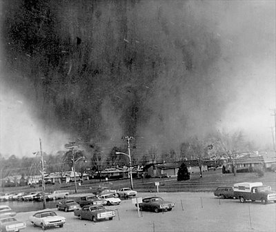
Tornado Outbreaks Then And Now - Apples And Oranges? The Weather Channel's Dr. Greg Forbes has an
interesting post about rating tornadoes over the years and asks the rhetorical question: is an F5 in 1974 really equivalent to an EF-5 in Joplin in 2011? And what about the trends - are tornadoes really on the increase? "
But it's also a "different world" in the way that tornadoes get rated. The mainstay of the original Fujita Scale used to rate tornadoes was that a home crushed into small pieces and blown away would earn an F5 rating, with wind speeds estimated at 261-318 mph. Engineers surveying the tornado damage back in 1974 began to tell meteorologists that it didn't take 300 mph winds to turn homes into piles of rubble and cast the pieces to the wind. Even well constructed concrete block and brick school buildings could fail in 220 mph winds, they said. And homes with damage apparently fitting an F5 description often happened because the house was not properly secured to its foundation in winds less than 150 mph. In the years since, these engineering analyses began to work their way into damage assessments, and in 2007 an Enhanced Fujita Scale (EF Scale) system was officially implemented. An EF5 tornado has winds estimated as low as 201 mph. And it's difficult to rate a tornado as EF5 based upon it just demolishing a house. Statistically, the number of tornadoes being rated 2-5 have been decreasing since the 1970s, despite the total number of tornadoes being recorded showing a dramatic increase. This is at least partly a consequence of the introduction of engineering concepts into the rating process. I was part of the team that developed the EF Scale, and it's a system that more accurately estimates tornado wind speeds. But it troubled me then (and still does) that it might be hard to compare past tornado outbreaks with future ones and determine which was worst. It's apples and oranges, to some extent, in the rating systems then and now."
* photo above of a massive, mile-wide tornado approaching Xenia, Ohio on April 3, 1974.
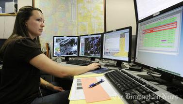
National Weather Service Union Warns Of Understaffing. This is probably not a good time to be cutting back on NWS employee staffing levels - during what has been the most severe 18-month stretch of weather on record, according to NCDC. The
Birmingham News has the story: "
Seven National Weather Service forecasting offices, including the ones in Birmingham and Huntsville, each need an additional three to six meteorologists, according to an internal analysis of workloads during the week of the April 27 tornado outbreak. The weather service employees union, which gave the report to The Birmingham News, called it a public safety issue needing prompt attention. An understaffed office could be slow to issue a warning or miss a dangerous weather development, the union contends. "I think lives can be saved by adding more people," said Dan Sobien, president of the National Weather Service Employee Organization, a union representing 4,000 employees in 122 offices nationwide. "People's lives are in your hands."
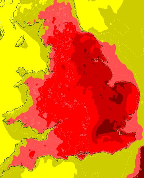
Hottest Weather So Far In 2011. The USA isn't the only country that's cooking through intense heat. England has been unusually hot, as described by
The MeteoGroup:
"As expected, Monday 27 June produced the highest temperature of the year so far with a weather station at Olympic Park (South) in east London recording a maximum of 33.3 degrees Celsius. Gravesend in northwest Kent was not far behind with a high of 33.1C. It was the hottest day anywhere in the UK since 19 July 2006, when Wisley in Surrey hit 36.5C, and is likely to be the most heat for the foreseeable future - the next couple of weeks anyway. It was also the hottest June weather since 7 June 1996. Temperatures rose above 30C across a wide area of the eastern half of England, from Yorkshire down to Surrey and Kent, but of course not everywhere was roasting. It sometimes seems to be forgotten that the UK stretches a good distance northwards and westwards. In Wales, parts of the coasts of Cerediggion, Gwynedd and Anglesey struggled to rise to 16C, while in Northern Ireland the northern Antrim coast couldn’t even get above 13 degrees - far lower than the east and southeast of England had as a minimum during the preceding night. In Scotland only a few locations in Berwickshire, Roxburghshire and Dumfriesshire scraped above 20C. Farther north, Glasgow has a maximum of 16.0C, Edinburgh (Gogarbank) 14.8C and Aberdeen just 14.0C."
BBC Scotland Is Having A Bad Day. Oops.
Gawker has the story (I feel for this woman, btw): "
You know those days where nothing seems to go right? And nothing you do seems to fix the problem? BBC Scotland is having one of those days, poor thing. It's okay, guys! No one knows what Rudolph Hess looks like, anyway. And who cares about the weather forecast? It's Scotland! The forecast is: Cloudy! With a chance of fried stuff!"
 After Losing To USA, The North Korean Soccer Coach Says His Team Was Hit By Lightning
. Sounds plausible to me. Details from the
Business Insider: "
After a respectable (but overmatched) defeat to the dastardly Americans, North Korea's women's soccer coach offered a perfectly valid excuse of this team's lackluster performance — half his team had been struck by lighting. Not during today's game, of course. But at the team's post-game press conference, coach Kim Kwang Min said that four players and a goalkeeper were hit by lightning on June 8th. As a result, those players weren't at full strength today and the team's strategy had to be altered. (The Guardian's John Ashdown has the full recap on his Twitter feed.) It wouldn't be the first time that this had happened to a soccer team and it would explain a great many things. However, no one else appears to have heard this story before today and the North Korean athletic department is not exactly known for its honesty and transparency."
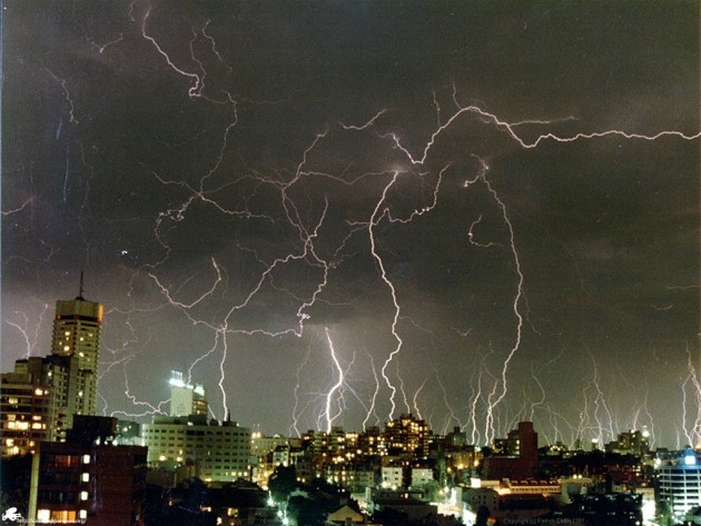
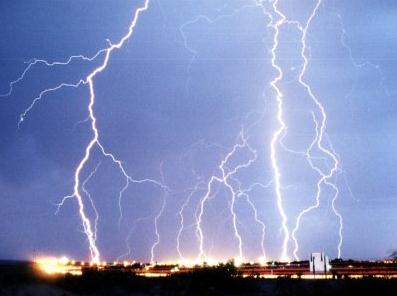
(Useless) Weather Trivia: at any given moment an estimated 2,000 T-storms are rumbling around the Earth.
Climate Stories...
Storm Warnings: Extreme Weather Is A Product Of Climate Change. 2010 may have been the most extreme year of weather since 1816, according to Dr. Jeff Masters, who heads up the Weather Underground. Is it possible to connect the dots and attribute some of these extreme weather patterns to climate change?
Scientific American has the story: "
These patterns have caught the attention of scientists at the National Climatic Data Center in Asheville, N.C., part of the National Oceanic and Atmospheric Administration (NOAA). They've been following the recent deluges' stunning radar pictures and growing rainfall totals with concern and intense interest. Normally, floods of the magnitude now being seen in North Dakota and elsewhere around the world are expected to happen only once in 100 years. But one of the predictions of climate change models is that extreme weather—floods, heat waves, droughts, even blizzards—will become far more common. "Big rain events and higher overnight lows are two things we would expect with [a] warming world," says Deke Arndt, chief of the center's Climate Monitoring Branch. Arndt's group had already documented a stunning rise in overnight low temperatures across the U.S. So are the floods and spate of other recent extreme events also examples of predictions turned into cold, hard reality? Increasingly, the answer is yes. Scientists used to say, cautiously, that extreme weather events were "consistent" with the predictions of climate change. No more. "Now we can make the statement that particular events would not have happened the same way without global warming," says Kevin Trenberth, head of climate analysis at the National Center for Atmospheric Research (NCAR) in Boulder, Colo."
Why The Insurance Industry Gets Climate Change. Among insurance industry analysts and military circles at the Pentagon there is little "debate" about the reality of climate change. The U.K.'s
Guardian has a timely story: "While climate zombies in Congress are lurching in lockstep toward environmental catastrophe, the insurance industry has been scrambling to act. It's well past time we listened to what they have to say. Insofar as the Republican party is the party of business, they might want to lend an ear as well. Insurance companies have a vested interest in reducing the risks of climate change.
Like scientists and the military, they're used to dealing with and planning for uncertainty. As scientists have made clear, climate change is cranking up the dial on extreme weather.
Over the last 30 years, catastrophic economic losses have been rising (pdf) with the global temperature, which chops into insurance firms' profits. With landscapes and livelihoods being sucked into the extreme weather vortex, insurance firm executives – especially in Europe – are getting the message.
The insurance industry is all about risk assessment and capital accumulation. Katrina-like catastrophes lurk on the discernibly warmer horizon, giving insurance companies a real deal incentive to slice against the zeitgeist of denial. As
Frank Nutter, president of the Reinsurance Association of America, told the select committee on energy independence and global warming in 2007, "The insurance industry's financial interest is inter-dependent with climate and weather."
Over the last five years, the insurance industry has become increasingly proactive on climate change, in terms of both underwriting and investment. Reinsurance companies – essentially firms that insure the insurers to manage and defray risk – have taken the lead. In September 2007, insurance firms formed
ClimateWise in order to reduce economic risk associated with climate change.
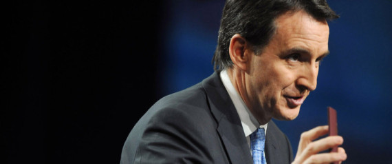
Pawlenty Skeptical That Humans Contribute To Climate Change. I like Tim (a lot), but many of his fans are disappointed with his apparent flip-flop on recognizing the scientific reality of climate change. Capitol Hill's
E2-Wire has the story: "
Climate change exists, but is due mostly to natural -- not manmade -- causes, GOP presidential contender Tim Pawlenty said Tuesday. Pawlenty, the former Minnesota governor who's rejected his past support for a cap-and-trade, said he believes the extent to which humans contribute to climate change is disputable. "So there is climate change, but the reality is the science of it indicates that most of it, if not all of it, is caused by natural causes," he said on Fox News. "And as to the potential human contribution to that, there's a great scientific dispute about that very issue." He isn't the only Republican presidential candidate to express skepticism toward the science of climate change. Former Sen. Rick Santorum (R-Pa.) has said "there's no such thing as global warming," and Rep. Michele Bachmann (R-Minn.) disputed in 2009 that human activity barely affects the amount of CO2 in the atmosphere. Former House Speaker Newt Gingrich (R-Ga.) has caught flack for appearing in a commercial with then-House Speaker Nancy Pelosi (D-Calif.) talking about the need to address climate change. But he's also labeled President Obama's energy policies as "anti-American," and talked about the need for more oil and gas exploration."
America, Awaken. I thought this
New York Times Op-Ed from Roger Cohen did a good job summarizing the challenge (and disappointment). I'd like to see a politician with the courage and will to explain how America HAS to reinvent itself as a greener, more sustainable nation, and how the drive toward self-sufficiency can generate new jobs and new industries focused on weaning America off carbon-based fuels. Who will that be: Obama, Romney, Huntsman? Who is going to step up and lay out a blueprint for renewal and reinvention? Lay out a vision. Surprise us. "
What’s most worrying is that the U.S. response to this crisis seems to be one of a country in middle age, a nation that has lost its can-do moral edge, the ability to come together and overcome. In this critical regard President Obama has failed to deliver. Berlin observed that Americans were a “2x2=4 sort of people who want yes or no for an answer.” They’ve gotten neither of late, only muddle. Bill Clinton recently took Obama to task in Newsweek, proposing 14 measures to create employment. Given that the Clinton presidency saw the creation of 23 million jobs his advice is probably worth a glance even if it grates. I was struck by two underlying themes: the need for an energy policy and for an industrial policy. Here’s why: It’s absurd that “climate change” has become an unpronounceable phrase under Obama and that green technology initiatives have been stymied by sterile ideological dispute. Intelligent use of resources makes strategic sense for America whatever your hang-up on global warming. It’s equally absurd that private U.S. corporations, having made $1.68 trillion in profits in the last quarter of 2010 and sitting on piles of cash, are doing fine while job numbers languish and more Americans struggle. None of this makes moral or any other sense. America needs an energy policy and an industrial policy. It has to lead in green technology and — purist capitalist reflexes notwithstanding — it must find ways to get corporate America involved in a national revival."
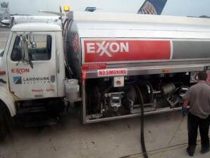
Did Exxon-Mobile Break It's Promise To Stop Funding Climate Change Deniers? Mother Jones has more details: "
Back in 2008, ExxonMobil pledged to quit funding climate change deniers. But according to new documents released through a Greenpeace Freedom of Information Act request, the oil giant was still forking over cash to climate skeptics as recently as last year, to the tune of $76,000 for one scientist skeptical of humankind's role in global warming. This—and much more—came to light in a new report about the funding of Wei Hock "Willie" Soon, an astrophysicist with the Harvard-Smithsonian Center for Astrophysics. Soon has been a favorite among climate skeptics for years, since coauthoring a paper back in 2003 that claimed that the 20th century was probably not the warmest, nor was it unique. That paper, published in the journal Climate Research, was widely criticized by climate scientists for its content, not to mention the funding it received from the American Petroleum Institute. An astrophysicist by training, Soon has also claimed that solar variability—i.e., changes in the amount of radiation coming from the sun—are to likely to blame for warming temperatures."
U.S. Climate Skeptic (Soon) Funded By Oil, Coal Firms. I'm shocked.
Reuters has the story:
* Funding came from Koch Foundation, Southern, Exxon, API
* Private science funding gets close look amid budget cuts
* Soon says never motivated by financial reward
By Timothy Gardner
WASHINGTON, June 28 (Reuters) - "
Willie Soon, a U.S. climate change skeptic who has also discounted the health risks of mercury emissions from coal, has received more than $1 million in funding in recent years from large energy companies and an oil industry group, according to Greenpeace. Soon, an astrophysicist at the Harvard-Smithsonian Center for Astrophysics, has also gotten funding from scientific sources including NASA and the Massachusetts Institute of Technology. But starting early in the last decade, Soon began receiving more funding from the energy companies, Greenpeace reported. Last year, the foundation of Charles Koch, chairman and CEO of privately held Koch Industries, gave Soon $65,000 to study how variations in the Sun are related to climate change. Koch is co-owned by David Koch, founder of Americans for Prosperity, a group aligned with the Tea Party movement, which opposes new air pollution regulations."