18,054 reports of severe weather across the USA so far in 2011. Source: SPC
1,549 tornadoes as of June 23.
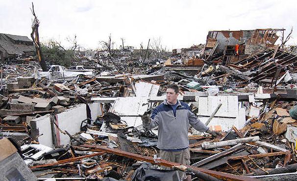
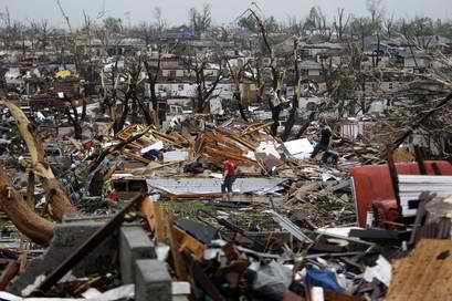
Alabama: 161 tornadoes, 244 fatalities - most in the USA.
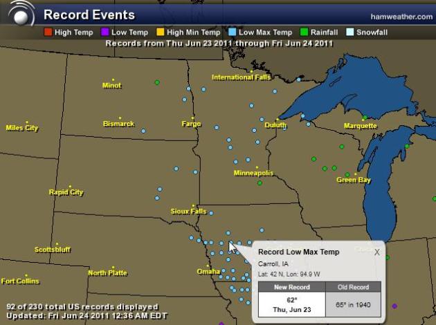
April Flashback. The sun is as high in the sky as it ever gets. Then why are Minnesotans fiddling with their furnace and wandering the yard in a light jacket? I have NEVER seen these kinds of temperature extremes in late June. Never. These extremes, in turn, are whipping up unusually strong storms, large and violent tornadoes, record flooding, etc. Click here to see an interactive map showing the "record low highs", or record cool maximum temperatures, courtesy of Ham Weather, a division of WeatherNation. Amazing.
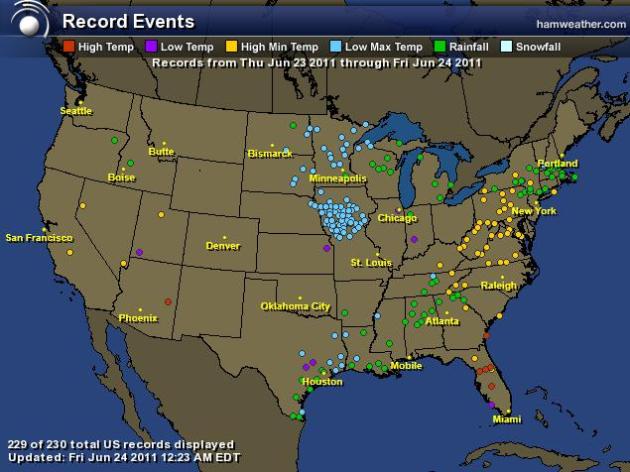
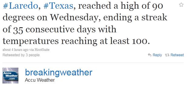
Superbowl Of Weather. I've said it before, but I really mean it this time. Record heat out west, record chill over the Upper Midwest, record rainfall from New England to Dixie. Click here to see all the interactive records for the USA - 230 just on Wednesday! Data courtesy of NOAA and Ham Weather.
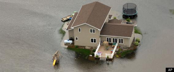
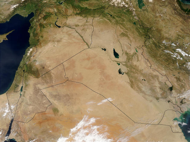
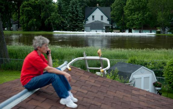
Minot, North Dakota Flooding: Thousands Of Evacuees Struggle To Find Places To Stay. A slow-motion tragedy is unfolding in Minot. Huffington Post has a recap of the challenges facing the estimated 12,000 people who had to flee their homes: "MINOT, N.D. -- Many of the thousands who have fled their homes as the Souris River spills into the North Dakota city of Minot have been scrambling to relocate in a region that boasts few vacancies in even the best of times, thanks largely to the state's oil boom. Officials said as many as 10,000 people had evacuated Minot by Wednesday, and while a few hundred were staying in temporary city shelters, many others were staying on friends' couches, under tents or even in vehicles. Aquira Fritt, 23 years old and 7 1/2 months pregnant, planned to spend the night in a van with her boyfriend and 5-year-old son. "There are no hotel rooms, no campers to rent, nothing," Fritt said Wednesday, shortly before emergency sirens blared to signal the evacuation deadline. "It's very stressful and it's very annoying." Her son, Azzyah, considered it an adventure. "He thinks it's a campout," Fritt said. "He's happy he gets a chance to use his sleeping bag." The water is expected to climb to record levels over the coming days in parts of this Air Force town as the little-known waterway swells from rain and snowmelt. Gov. Jack Dalrymple warned that releases planned to begin on Thursday would be dramatic. "In two days' time, it will be a rapid, rapid rise," Dalrymple said. The river, which begins in the Canadian province of Saskatchewan and flows for a short distance though North Dakota, was all but certain to inundate thousands of homes and businesses during the next week."
North Dakota Authorities Order Expanded Evacuation in Minot as Souris River Rises Rapidly. The Star Tribune has the story: "MINOT, N.D. - North Dakota authorities expanded an evacuation order Thursday for the state's fourth-largest city, citing danger from the rising Souris River. It wasn't immediately clear how many residents were affected. National Guard Capt. Dan Murphy said officials were still examining maps and planned to release more information later. "The bottom line is they're just trying to get everybody out of the area where they think the property is going to be inundated," Murphy said. As many as 10,000 residents were evacuated a day earlier as the Souris, swollen by heavy rains and snowmelt, threatened. On Thursday, officials accelerated the release of water from the Lake Darling dam upstream and said it could raise the river 2 to 3 feet higher than earlier projections. Officials also announced the closure of the Broadway Bridge, shutting down a key north-south artery in the city. Minot Mayor Curt Zimbelman said the record flow of water into the city will test its sewer and water systems. "We're very concerned, especially with the backups in the sewer system. We've had several areas where we've had crushed sewer lines," Zimbelman said. "With those types of things happening, it's at the top of our minds all the time.
- 12,000 residents have evacuated Minot, ND this morning. That is just under a third of the total population of the town - 41,000
- Locals call the Souris "The Mouse" after the French translation of its name
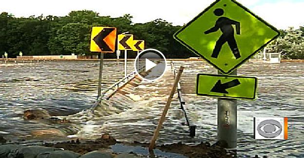
- Souris has already past flood stage by more than a foot
- may be 4 feet above record by Monday
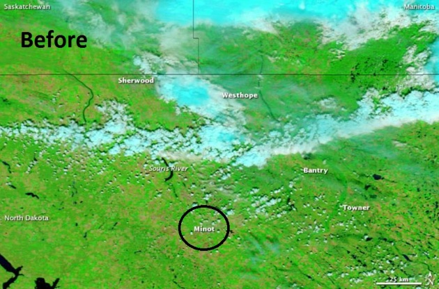
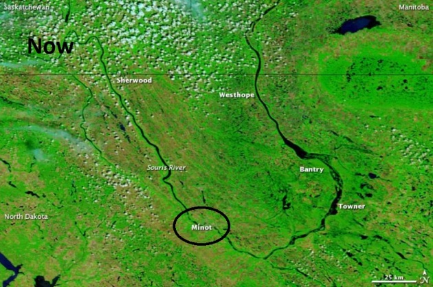
Minot Flooding From Space. NASA's Earth Observatory has a time-sequence showing the record flooding on the Souris River. The image on the left was taken June 24, 2010 - the image on the right taken from low orbit on June 23, 2011. More details: "On June 22, 2011, the U.S. National Weather Service (NWS) forecast record flooding for multiple locations along the Souris River in North Dakota. Sherwood, Minot, Towner, Bantry, and Westhope were some of the communities expecting record flooding. On June 23, 2011, Advanced Hydrological Prediction Service (AHPS) of the U.S. National Weather Service reported major flooding of the Souris River in or near all of these locations. The Moderate Resolution Imaging Spectroradiometer (MODIS) on the Terra satellite captured these images on June 23, 2011 (top), and June 24, 2010 (bottom). Both images use a combination of visible and infrared light to increase contrast between water and land. Water varies in color from electric blue to navy. Vegetation is green. Bare ground and fallow fields are earth-toned. Clouds are pale blue-green. Parts of the Souris River disappear from view in the scene from 2010, but the river is clearly visible throughout its path a year later. In this satellite view, the river appears especially swollen near Bantry and Towner, but the Souris actually overtopped levees in Minot, according to the NWS. A sharp rise in the water level occurred near Sherwood overnight June 21 and 22, and the AHPS forecast a significant rise in river level near Minot around June 24."
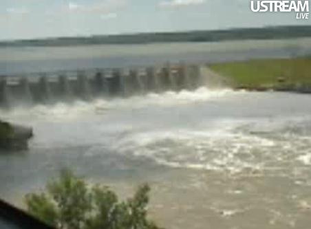
Live Stream. Here is a live stream of the water raging through the Gavin's Point Dam in Yankton, water flowing downstream toward Minot (and the Missouri River). Record snows in Montana and Wyoming are melting rapidly, adding to the run-off. Video courtesy of UStream.
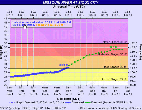
National Weather Service Reviews Confusing Forecasts For Missouri River. The Des Moines Register has the story: "The National Weather Service is reviewing its forecasts for the flooding Missouri River today as the Mighty Mo rises less than expected near Sioux City while officials near Hamburg fear a steep rise. Jeff Zogg, a weather service hydrologist based in Des Moines, acknowledged that forecasts calling for the river to fall in the next few days in much of Iowa seem odd when the U.S. Army Corps of Engineers is increasing the flow from Gavins Point Dam upstream in South Dakota by 10,000 cubic feet per second, to 160,000. “We’re wondering the same thing,” Zogg said. “We aren’t seeing the rise in the river we expected at Sioux City,” where the Corp predicted a foot and a half rise in the river, but weather service forecasters expect a half-foot by Sunday. “We’re taking a look at that today.” Fremont County officials said the river is rising near Hamburg, and they fear it may even go over one stretch of levee. That would most likely mean a breach. See related post here."
- Total severe weather (hail/wind/tornado) reports so far this year - 18,054
- 1549 of those are tornadoes.
- Alabama now ranks first for number of EF-5 tornadoes (7 since 1950).
- Was previously tied with TX, IA, KS, OK with 6 apiece.
- Total of 161 tornadoes reported in Alabama this year.
- Also has the highest number of tornado fatalities this year (244 deaths).
- “Dixie Alley” often has just as many tornadoes as the traditional “Tornado Alley”, with two peak seasons -- primary is March-April, secondary is October-December.
Why are there so many deaths despite warnings?:
RT @BobRyanABC7: AMS conference: Average for tornado warnings still false alarm rate of 75%*Concern for public apathy with too many warnings
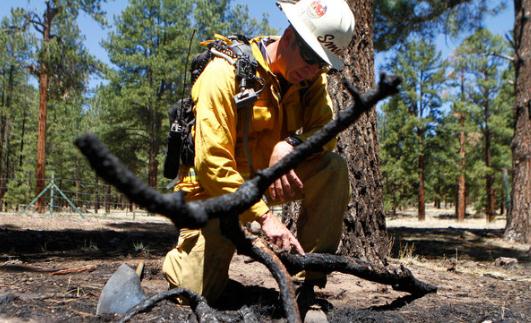
Fighting Fires With Computers And Intuition. The New York Times has a good story about new technology, and how it's helping firefighters battle what will almost certainly go down in the books as one of the most severe years for wildfires in U.S. history: "PHOENIX — As thousands of firefighters used hand tools and hoses to combat the wildfires torching vast stretches of the Southwest, Drew Smith stared into a computer screen at a command center near one of the fiercest blazes and tried to determine which way the flames would veer next. Some wildfires are mean. Some are wily. Some show exceptional endurance, or fierceness or moxie. The most difficult among them are assigned behavior analysts like Mr. Smith — fire whisperers, as it were — who act as psychologists delving into the blazes’ inner selves. “This fire is an exceptionally aggressive fire based on how large it has become and how fast it’s growing,” said Mr. Smith, now assigned to the Wallow Fire, which has become the biggest blaze in Arizona history after burning more than 527,000 acres in the eastern part of the state. Fire behaviorists work alongside meteorologists, given that the weather, especially wind patterns, plays a pivotal role in how a wildfire grows. The topography is also important because fires burn differently depending on whether they are going up a steep slope, across a valley or through a developed area. Then there are what firefighters call the fuels, which are the vegetation and other materials that give fires energy as they move along. With more than a dozen significant fires now burning through the Southwest, the fire whisperers are busy. At the sunrise briefings that wildland firefighters attend before they go off to the lines, a variety of status reports are offered on the day’s work ahead. None, though, is listened to as intently as that of the behaviorist, who uses computer modeling and intuition to try to predict how the fire will burn that day."

* Hey, is that gal really a TV meteorologist? Does it even matter?

Climate Stories: