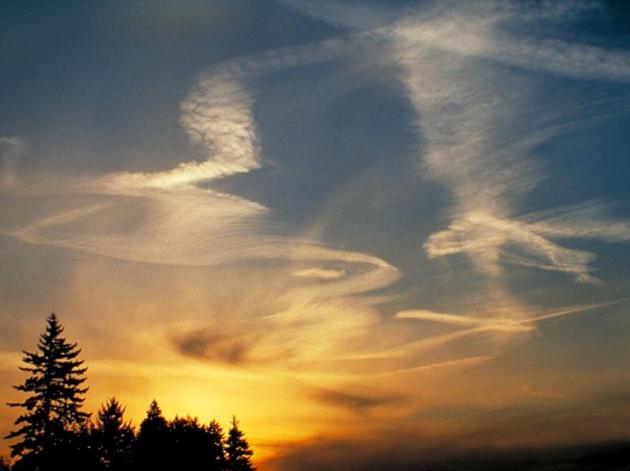
Half a November
It's
a little odd shivering through the chill without any snow on the
ground. Perpetually-frustrated snow lovers are starting to feel cheated
again.
A paltry inch of wet snow has dribbled on the Twin Cities
this month. We should have picked up over 7 inches by now. Adding insult
to injury much of north Texas and the hills of Georgia have picked up
more snow than MSP this month.
Another upside-down weather map.
If
you listen carefully you can almost hear the gnashing of teeth and
shrieks of frustration from travelers out east. A coastal storm soaks
D.C., New York & Boston with 2-3 inches of rain; heavy snow cakes
the Appalachians on the busiest travel day of the year. Proving that Old
Man Winter has a wicked sense of humor.
A scrawny clipper brushes
the Arrowhead with 1 inch of snow today; otherwise plan on dry skies
(and roads) into the weekend with slowly moderating temperatures. Mid
30s return the first half of next week with a little snow or mixed
precipitation.
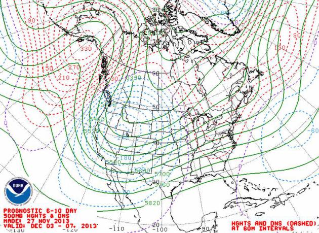
I still don't see The Big One.
Temperature
may fall off a cliff in 8 days: single digits & low teens with
subzero lows after December 4? But major storms detour well south and
east of Minnesota into mid-December.
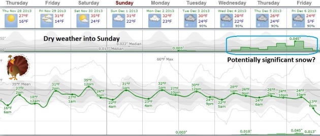
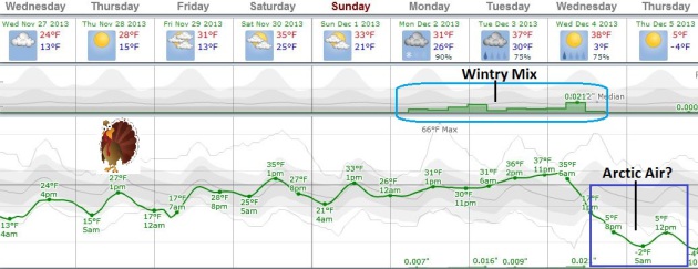
Easy Traveling Into Sunday.
ECMWF guidance shows a slow warming trend into the weekend. Low to mid
30s is not atmospheric bargain, but compared to Tuesday's sting it
should feel pretty good out there by Saturday and Sunday. The approach
of a much colder front may set off wet snow, or a wintry mix Monday and
Tuesday. Temperatures may plummet by the middle of next week, early
guidance showing a "high" of 5 a week from tomorrow. Graph:
Weatherspark.
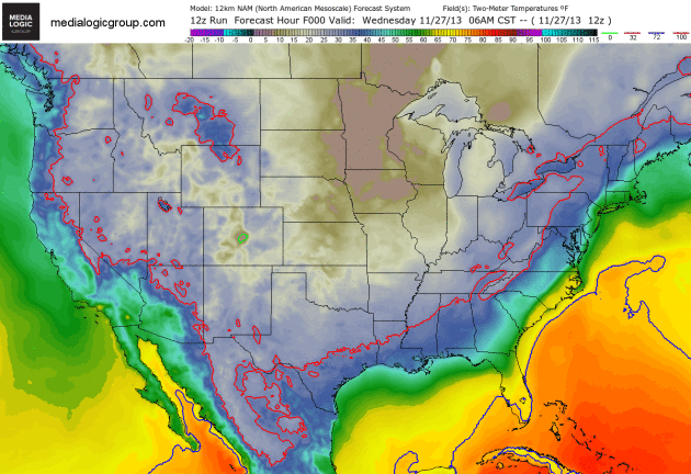
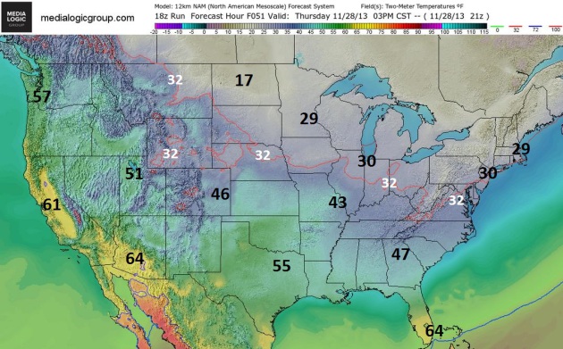
Thanksgiving Highs.
With a low sun angle and short duration of daylight maximum
temperatures take place early in the afternoon. The map above shows 3 PM
temperatures on Thursday, courtesy of NOAA's 12km NAM and Ham Weather.
Thanksgiving Weather Details.
We lucked out here in the Upper Midwest, but folks out east are not
taking quiet weather for granted, not today. The most traveled day of
the year is a rainy, windy, icy, snowy mess. A surge of cold air on the
backside of this powerful coastal storm will push the freezing line to
the Gulf Coast and Florida Panhandle - highs in the 50s over south
Florida Thanksgiving Day. Brrr. Hey, we grill at that temperature here
in Minnesota, but everything is relative. More travel weather details,
and late November tornado climatology in today's edition of
Climate Matters.
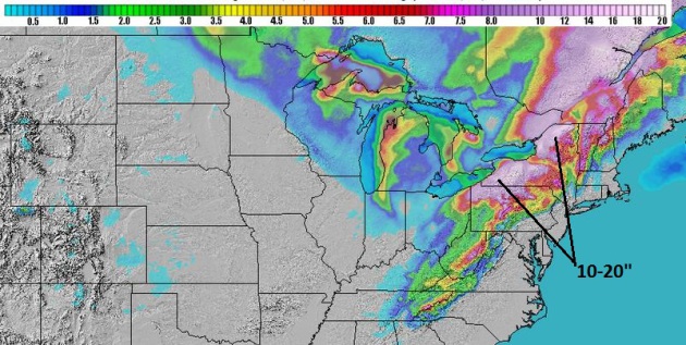
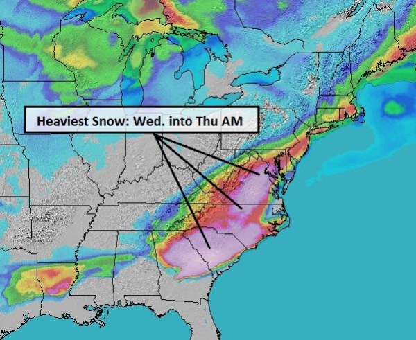
Snowfall Totals.
The heaviest snow bands are forecast to set up from northwestern
Pennsylvania into upstate New York and northern New England. Lake Effect
snows will drop some 5-10"+ amounts over the U.P. of Michigan and
northern Indiana. NAM 84-hour snowfall courtesy of NOAA and Ham Weather.
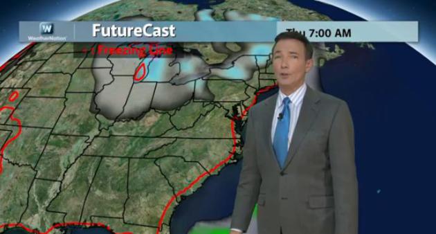
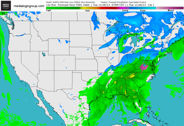
Exit Stage Right.
Today will test your patience if you're traveling anywhere from the
Great Lakes and New England to the Mid Atlantic states; heavy rain
pushing up the east coast, changing to heavy snow over the Appalachians.
The good news: this storm will be well out to sea by Thanksgiving Day.
4km NAM Future Radar courtesy of NOAA and Ham Weather.
Everything You Know About Getting Warm Is Wrong.
Huffington Post
has a timely article about methods for staying warm in the coming
months; what works, and what just makes the situation even worse. Here's
an excerpt: "...
Drinking alcohol lowers your core body temperature, increases your risk for hypothermia and prevents your body from naturally shivering to keep warm.
The reason why you feel warm while drinking alcohol is that your blood
vessels dilate and send warm blood away from your core and towards your
skin. This effect is only temporary and in the end significantly
decreases your body's ability to fight the cold..."
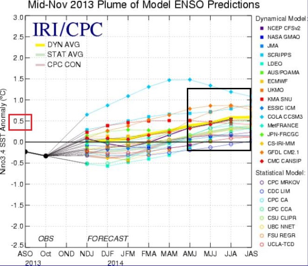
Growing Signs Of El Nino In 2014. The graphic above is from NOAA's latest
ENSO update;
after years of a perpetual La Nina cooling phase of the equatorial
Pacific there are growing signs of a possible El Nino warming phase
developing by early 2014; which may, in turn, favor milder than normal
temperatures, and a southern storm track across the USA into the latter
half of winter. It won't be declared an official El Nino event until and
unless we go at least 3 consecutive months with sea surface
temperatures .5C warmer than average.
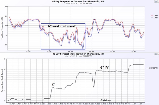
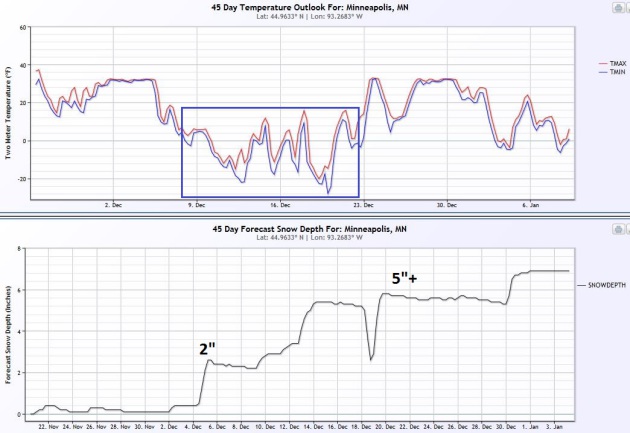
45-Day Wish-Cast.
My confidence level is low (a -1 on a scale from 1 to 10), but I find
these long range CFS (Climate Forecast System) forecasts from NOAA CPC
interesting. I'm trying to determine if there is ANY skill here. The
latest forecast calls for an arctic snap between December 8-20, with a
slight warming trend in time for Christmas. The model shows 2" of snow
on the ground by December 5, about 5"+ on the ground in time for
Christmas Eve. Place your bets.
Alerts Broadcaster Briefing: Excerpt of a summary issued Tuesday, November 26, 2013.
*
The most ill-timed storm of 2013 is pushing heavy rain and snow up east
coast; heavy rain still likely for eastern seaboard - plowable snows
for the Appalachians, Blue Ridge Mountains and Shenandoah Valley.
Heaviest snows expected over western Pennsylvania and upstate New York.
* 2-4" rains along and east of I-95 later today, tonight and Wednesday morning will trigger sporadic urban flooding.
*
Travel by land and air will continue to be disrupted; the worst of the
storm along the I-95 corridor from Tuesday evening into Wednesday
morning.
* Storm pushes into the Atlantic by Thanksgiving Day - no problems on Thursday.
*
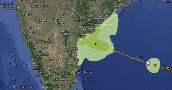
Typhoon Lehar
forecast to strike the eastern coastline of India (Andhra Pradesh
region) as a strong tropical storm or weak hurricane Thursday.
Snowfall Potential.
Snowfall amounts will be tied to elevation; higher terrain of the
Appalachians will nudge precipitation from rain over to snow, with
enough to shovel, plow and snarl traffic from near Asheville, North
Carolina into eastern Kentucky, eastern Ohio and much of central and
western Pennsylvania and New York state - enough snow to cause problems
generally west of I-81. NAM model: Ham Weather.
Another Solution.
The RPM model isn't nearly as impressive in terms of snowfall totals,
but I'm a little skeptical about this solution. It shows the axis of
heaviest snow from near Youngstown, Erie and Buffalo to Rochester and
Syracuse, which is realistic. Little or no snow is expected east of
I-95. Map: WSI.
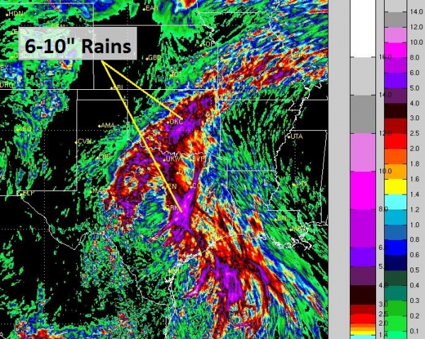
A Burst of Torrential Rain.
Most eastern cities will experience a 6-10 hour period of moderate to
heavy rain - as much as 2-4" from near Charlotte to Washington D.C., New
York, Hartford and Boston, triggering urban and small stream flooding
(and excruciatingly slow commutes and travel times) later today into
Wednesday morning. Map: NOAA.
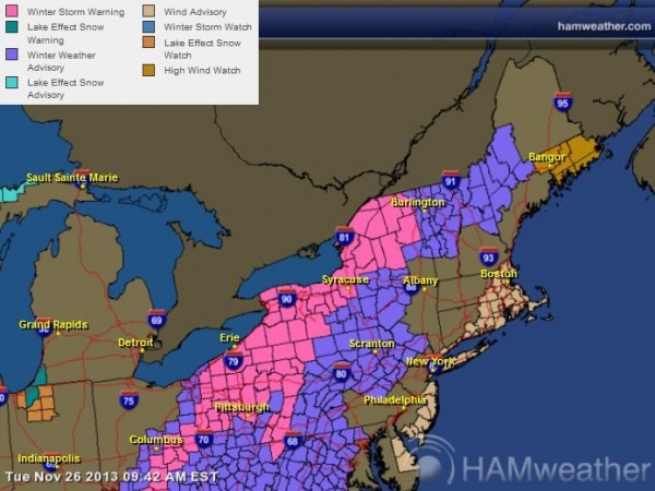
More Warnings.
The heaviest swath of snow comes from south and east of Columbus to
Pittsburgh, Erie, Buffalo, Rochester and Syracuse, where Winter Storm
Warnings are in effect. Winds along the Atlantic coastline will gust
into the 25-40 mph range tonight and early Wednesday. The latest
warnings from NOAA and Ham Weather are
here.
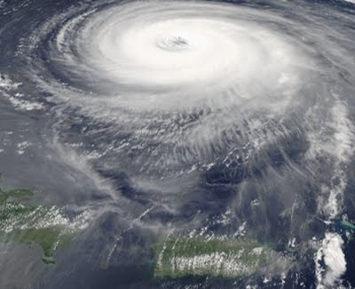
Typhoon Lehar.
Just when you thought typhoon season might be finally drawing to a
close, along comes "Lehar". A moderate typhoon with sustained winds of
95, gusts over 110 mph, Lehar may strengthen slightly before weakening
as it approaches Vijayawada, India by Thursday as a strong tropical
storm or Category 1 hurricane/typhoon.
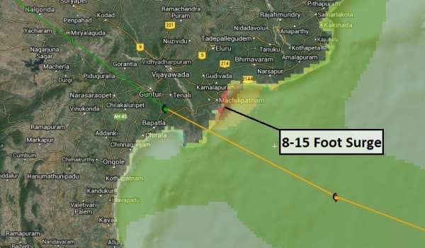
Significant Storm Surge Potential.
Our models show a risk of a 5-15 foot storm surge east of Vijayawada,
near Machilipatnum as the center of the storm pushes ashore Thursday,
which seems high for a (predicted) Category 1 typhoon at landfall. We'll
keep an eye on storm surge predictions, which proved to be the biggest
killer from Typhoon Haiyan (death toll in the Philippines is now over
5,000). One lesson from Haiyan: locals react to the word "tsunami" -
they can grasp the potential for destruction. The term "storm surge" was
not well understood or appreciated in the Philippines, leading to
confusion and a higher death toll as people remained in their homes,
close to sea level.
Summary: A major storm is now
pushing out of the Gulf of Mexico, tracking right up the East Coast
Wednesday. This will be a (heavy) rain event for most of the east coast,
with heavy, wet snow over the Appalachians, some accumulating snow as
far west as Lexington, Kentucky and Columbus, Ohio. The arc of heaviest
snow tracks from western Pennsylvania into upstate New York, with some
10-18" amounts possible near Syracuse and Rochester. For the major east
coast city centers this will be a heavy rain event, and travel
plans/commutes will be disrupted over the next 36 hours. Lousy timing,
but I'm reminded of this uncanny fact: storms (given a choice) prefer to
come right before major holidays.
Paul Douglas - Senior Meteorologist - Alerts Broadcaster
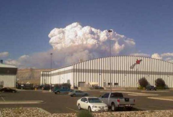
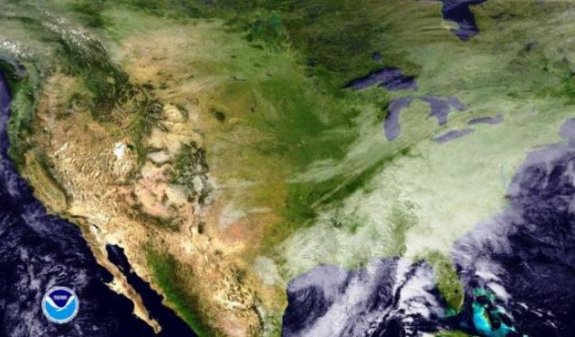
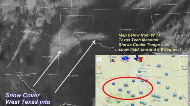
Ski Texas.
Tuesday's visible satellite image clearly showed freshly fallen snow
over the Texas Panhandle, extending into southwestern Oklahoma. Image
courtesy of the
Lubbock office of the National Weather Service.
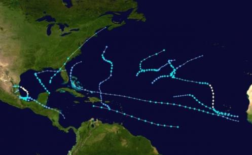
Least Active Atlantic Hurricane Season In 30 Years. Meteorologist Andrew Freedman has a good summary of a head-scratcher of a hurricane season at
Climate Central; here's an excerpt: "
Defying dire outlooks
issued in the spring, the 2013 Atlantic hurricane season, which
officially ends Nov. 30, was the least active since 1982, and the
sixth-least-active season since 1950, the National Oceanic and
Atmospheric Administration (NOAA) said on Monday. There were no
landfalling hurricanes in the U.S. in 2013. In fact, it has been more
than 8 years since the last major hurricane of Category 3 intensity or
greater struck the U.S., a record stretch. The last major hurricane
strike occurred in 2005, when Hurricane Wilma hit Florida. When the
start of the 2014 Atlantic hurricane season rolls around on June 1,
2014, it will have been 3,142 days since that storm made landfall, a
record timespan..."
Graphic credit above: "
Map of 2013 tropical storm and hurricane tracks." Credit: Wikimedia Commons.
The Pioneers Of Seasonal Hurricane Forecasting Might Stop Doing It. They insist it has nothing to do with this year's poor track record, as reported by SFGate.com; here's a clip: "...Many
seasonal forecasters predicted that overall activity — measured in
terms of the number of storms, their intensity and their duration, would
be as much as twice as high as average levels. Instead activity was
only about 30 percent of typical levels, or one of the five quietest
years in the last half century of Atlantic hurricane seasons. Now comes
word that the dean of seasonal forecasting, William Gray and his
co-author Phil Klotzbach, of Colorado State University, may be ending
their forecasts. It has nothing to do with their poor forecast this
year, they say..." (Image credit: NASA).
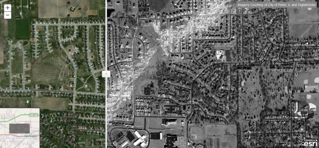
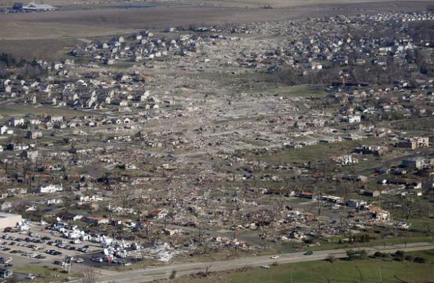
Before And After The Tornadoes In Illinois. ESRI
has an interactive URL that shows the severity of damage in Washington
Illinois, after an EF-4 tornado bull-dozed its way across the center of
town on November 17.
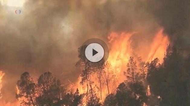
The Silent Triumph: Weather Warnings Saved Hundreds Of Lives In Midwest Tornado Outbreak.
106 tornado reports on November 17, some as far north as Michigan -
unprecedented in their violence and how late in the season they formed
this far north. Here's a clip from
Capital Weather Gang, a quote from meteorologist Mike Smith that resonated: "...
The
lower death toll from this week’s storms was not inevitable; it is the
result of a half-century of scientific discovery and technological
development: Doppler radar, weather satellites, lightning detection
networks and smartphone apps. It is a result of volunteer storm chasers
instantly reporting the most violent tornado (the Washington, Ill.,
storm) when it first touched down near Pekin.
No other nation
enjoys the quality and breadth of meteorological services available in
the United States. It is an area in which federal dollars are put to
valuable use and leveraged through the efforts of private-sector weather
companies such as AccuWeather, and by meteorologists and emergency
managers.
File photo above: AP Photo/Charles Rex Arbogast.
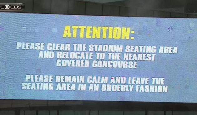
Special Report: Storming The Field.
Fans sitting in a stadium are sitting ducks when it comes to weather,
especially extreme weather. New technologies, apps and alerts can help,
but it pays to be continually weather-aware. Don't depend on anyone else
for your safety, or the safety of your family. Here's an excerpt of a
story at
WTVM.com in Columbus, Georgia: "...
It
could be dangerous, but where are you supposed to go?" asked former
Auburn kicker Al Del Greco. Tornadoes can happen anywhere, even at
football stadiums. The good news is that tornado safety has changed
since 1983. Just this season, the South Carolina/North Carolina game was
delayed and the stadium was evacuated after a severe storm with
lightning moved in during the second half. Colleges and universities now
have rules in place, and it starts with the suspension of play. "If we
left the game playing, nobody's going to leave. They're not going to
take it serious. They're going to sit there and keep watching as long as
it's playing," explains Chance Corbett, the Auburn director of public
safety..."
Stock Returns Affected By Weather, Says Study. Say what?
Valuewalk.com has a story that made me do a triple-take; here's an excerpt: "
The Quant Research Team at www.empiritrage.com has drawn attention to a recent study
by William Goetzmann, Dasol Kim, Alok Kumar and Qin Wang which shows
that weather-based indicators of mood impact perceptions of mispricing
and trading decisions of institutional investors. According to
Empiritrage analyst William N. Goetzmann, “It is interesting because it
points out that weather may affect highly educated investors, and that
it would be interesting to see how the temperature (as opposed to
cloudiness) affects stock returns...”
Researchers Track Outdoor Air Temperatures By Measuring The Battery Temperatures Of Smartphones. Here's an innovative way to track hyper-local changes in air temperature, as described in this clip from
Inside Science: "...
On
the other hand, Georgescu's ASU colleague David Hondula, who was not
involved in this study, wants to use smartphones to track the heat
exposure of individuals. "If your phone is tracking your weather
conditions, you might have a personalized alert that you have
experienced excessive heat as you've moved through your daily life,"
said Hondula. When informed of their heat exposure, people can take
steps to protect their health, and thus reduce heat-related mortality.
In Hondula's words, "There's certainly the potential for many important
questions to be answered, if everyone's walking around with a potential
environmental monitor in their pocket."
Which Side Of The Barricade Are You On?
Is the American Dream still achievable, or is the game rigged, gamed,
only to favor a small percentage of the elite? Here's an excerpt of an
interesting read at
Politico: "...
At
the core of Americans’ anger and alienation is the belief that the
American Dream is no longer attainable. Previous generations held fast
to the promise that anyone who worked hard and played by the rules could
get ahead, regardless of their circumstances. But increasingly,
Americans have concluded that the rules aren’t fair and that the system
has been rigged to concentrate power and wealth in the hands of a
privileged few at the expense of the many. And now the government is
simply not working for anyone. Americans’ long-brewing discontent shows
clear signs of reaching a boiling point. And when it happens, the
country will judge its politicians through a new filter—one that asks,
“Which side of the barricade are you on?..."
Only 25% Of Yahoo's Employees Use Yahoo Mail? Yes, there's a little disconnect here, as described by Kara Swisher at
All Things Digital: "
As
most know, I love a good internal memo from inside Yahoo and here’s a
doozy related to a rather controversial topic of late: How badly the new
version of Yahoo Mail has been received by consumers. As has been
widely reported, a relentless and vocal group of Yahoo Mail users have
been complaining vociferously after the Silicon Valley Internet giant
drastically revamped its popular Mail service in October. The ire
includes a lot of distress over the removal of its tabs function and the
addition of a multi-tasking feature in its place..."
Climate Stories...
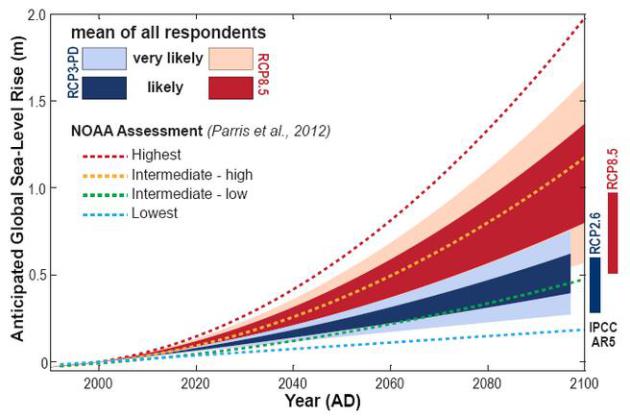
Research Suggests Future Global Warming Has Been Underestimated.
UPI has the article - here's a clip: "
Global
warming could go on for centuries even with a complete stop of CO2
emissions and then stabilize at an even higher temperature, a Swiss
scientist says. Researcher Thomas Frolicher says computer models
contradict the assumption by many scientists that global warming would
come to an end if, some day, humans succeed in ending the release of
greenhouse gas emissions into the atmosphere. Frolicher and U.S.
colleagues report they've used a model that represents physical and
biogeochemical processes -- such as the exchange of greenhouse gases and
heat with the oceans -- at a far more detailed level than many previous
models..."
What 11 Billion People Mean For Water Scarcity.
Yahoo News has the story - here's the introduction: "
The
water woes plaguing the Southwest foreshadow a worldwide problem to
come. Already, 2.7 billion people globally face at least some water scarcity,
according to a 2012 study detailed in the journal PLOS ONE. Fights over
water rights are causing political conflicts and instability in such
places as the Nile valley and the Indian subcontinent. As population
sizes rise, those conflicts will get more intense, according to a report
by the National Intelligence Council, which advises the director of
national intelligence for the United States about national security
issues. And the latest population models predict that 11 billion people will live on Earth by 2100, according to a United Nations report released last summer..."
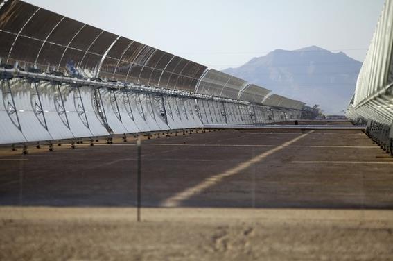
On Campuses, A Fossil Fuels Divestment Movement.
The Washington Post has the story - here's the introduction: "
A
divestment movement is marching across U.S. college campuses, borrowing
tactics from the 1980s anti-apartheid campaign and using them against
oil, gas and coal companies to fight climate change. Students are
teaming with investment advisers to convince universities, pension funds
and institutional investors that they can take a stand against
fossil-fuel companies without hurting their returns. “We have a
government that has been taken over by the fossil-fuel industry, so
we’re going to pressure the fossil-fuel industry itself,” said Chloe
Maxmin, a junior leading Divest Harvard..." (Image: Clean Technica).
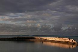
Global Warming Threatens Pacific Economies, Report Says. Here's an excerpt from Real Time Economics at
The Wall Street Journal: "...
Rising
temperatures might sound nice for people planning a beach vacation. But
for Pacific Island nations, global warming poses a big threat to their
ability to capture tourist dollars, according to the Asian Development
Bank. In a report Tuesday,
the Manila-based lender says sun-baked tropical nations from Samoa to
the Cook Islands that rely on tourism income could become less
attractive destinations as global temperatures rise..."
Photo credit above: Reuter. "
A wall built to protect people from rising tides in the Pacific island nation of Kiribati."
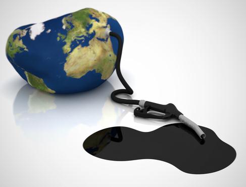
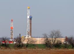
U.S. Methane Study Says Emissions 50% Higher Than EPA Estimates. Here's an excerpt from a story by the AP and
Huffington Post: "
The
United States is spewing 50 percent more methane — a potent
heat-trapping gas — than the federal government estimates, a new
comprehensive scientific study says. Much of it is coming from just
three states: Texas, Oklahoma and Kansas. That means methane may be a
bigger global warming issue than thought, scientists say. Methane is 21
times more potent at trapping heat than carbon dioxide, the most
abundant global warming gas, although it doesn't stay in the air as
long. Much of that extra methane, also called natural gas, seems to be
coming from livestock, including manure, belches, and flatulence, as
well as leaks from refining and drilling for oil and gas, the study
says. It was published Monday in the Proceedings of the National Academy
of Science..."


