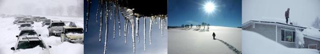
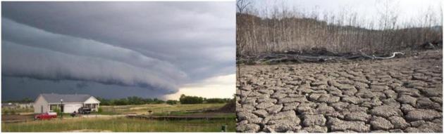
Tuesday, December 3, 2013

Potentially Record Arctic Cold Wave About To Push Across USA


The Polar Plunge

Minnesota is about to get its cold weather boasting rights back. Winters have been trending wimpier over time - but every now and then we get whacked. Prepare for a significant whacking.
Then again this is the price we pay for living in paradise. California gets earthquakes - hurricanes torment the Gulf and East Coast - tornadoes terrorize the Great Plains. At least Siberian air leaves our homes intact and upright, it's shivering inhabitants suddenly counting the days until spring. An inconvenience, but no need to call out the National Guard.

Why is MSP always on the EDGE of big snows? An icy mix triggered by a thin layer of above-freezing air aloft may keep snowfall amounts down - but a plowable accumulation of 1-3 inches is still possible; much more north of the metro. This will be a snowmobile-worthy snowfall up north; up to 2 feet for the North Shore of Lake Superior.

Today's burst of ice & snow marks the leading edge of frigid air. The next week will bring 5 subzero nights, in fact daytime highs may hold below zero Saturday, again Tuesday of next week. A few more inches of snow may fall late Sunday into Monday.

Before you consider moving in with Uncle Earl in Naples, long-range guidance shows 20s (above zero!) later next week.

Gasp.

High Resolution WRF Model. The 00z run of the 4km WRF (above), courtesy of the Twin Cities National Weather Service, shows a 2-4" range across the metro, 1-2" south metro, closer to 3-4" north metro, with some 6-8" amounts closer to Brainerd and Wadena.

Tight Snowfall Gradient. The NAM model shows as much as 5-6" over the northern suburbs, which is possible, if we don't see sleet or freezing rain mixing in this morning. As much as 15-20" or more may plaster the North Shore of Lake Superior. The ski buffs up at Lutsen have to be smacking their lips. Fresh Minnesota Powder. Map: NOAA and Ham Weather.

A Whole New Level Of Cold. Think this is cold? Not really, not compared to how it's going to feel by Friday as one of the coldest airmasses in a decade plows south of the border. I suspect highs may hold in low single digits Friday, possibly not rising above 0F on Saturday before slight recovery on Sunday. The solid green line marks the location of the 0F isotherm, the red line is the freezing line. Oh to be only freezing. Map: NOAA NAM and Ham Weather.

One Unpleasant White Spot. Here's a graphic and comment I received from Dean DeHarpporte, a consulting meteorologist here in the Twin Cities: "Paul, I cant resist sharing with you this GFS 850mb prog for next Tuesday Dec. 10, at 12Z. I cant remember ever seeing a white color on this map, which is the coldest color classification available (- 30C). The fact that it is centered directly over Minnesota is quite astounding." (map: College of DuPage).

A Few Record Lows? ECMWF guidance from weatherspark (above) shows double-digit subzero lows Friday, Saturday and again next Tuesday morning. The "Euro" may be overdoing the cold a bit, but I suspect it has the right idea. Which brings up a metaphysical question: can you feel any colder than numb? Teens will feel good by the middle of next week. Only in Minnesota could the weatherguy get away with saying that.

Warming Signal Third Week of December? The AO (Arctic Oscillation) is a fairly reliable leading indicator of future temperature trends. I'm oversimplifying a bit, but when it's positive much of the USA trends milder, when it's negative we cool down. You can see the sharp drop in the AO over the next week, coinciding with truly bitter air, but it blips upward by December 15-16, suggesting some moderation. Then again, it can't get much colder. Chart: NOAA.

A Reason To Keep On Going. GFS guidance seems to confirm the AO signal mentioned above; highs reaching the 30s to near 40 (above zero!) after December 17. Hang in there - it won't stay Nanook for the entire month of December.

Bitter Outbreaks In A Warming World. How on Earth can we get arctic "invasions" if the atmosphere is warming? It's a good question. Nature rarely moves in a perfectly straight line, and that certainly applies to the atmosphere. As one climate scientist told me recently "if we ever get to the point where we don't see cold fronts or snow we'll be too far gone to do anything about climate change." The reality: in spite of a warmer atmosphere (globally) and rapidly warming oceans, bitter air will still find its way into the USA when prevailing jet stream wind patterns are favorable. As they will be over the next week or so. We focus on the coming cold wave and cold vs. warm weather records for the USA in today's edition of Climate Matters: "WeatherNation Chief Meteorologist Paul Douglas looks at the coming cold snap for the United States and shows the bigger picture of the overall warming trends. This is the first time in 20 years that there were more cold weather records than warm weather records, and how does it play into the overall climate picture?"


Federal Agency Releases Joplin Tornado Study. No building will ever be tornado-proof, but how can we strengthen national building codes to make commercial and residential buildings more tornado-resistant? Here's a clip from The Washington Post: "...The overarching conclusion of our two-year study is that death and destruction from tornadoes can be reduced,” said Eric Letvin, the institute’s director of disaster and failure studies. “Our scientific understanding of tornadoes and their effects has matured substantially,” he added. “It’s time to begin developing and implementing nationally accepted standards and codes that directly address tornado hazards.” The May 2011 Joplin tornado killed 161 people and destroyed thousands of buildings, including homes, churches, businesses big and small, and one of the city’s two hospitals. The study found that all but 26 of the deaths came from building collapses..." (Images above: NOAA).

America's Southern States, From Sunbelt To Stormbelt. Here's a clip from a photo essay at The Guardian: "When Robert Leslie first visited the US as a child in the late 1960s, it was the world's most productive country, driven by the sunbelt stretching across the south from Florida to California. Stormbelt is a collection of photographs taken between 2009 and 2012, when Leslie returned to the region. What he found was an area battling not just the economic recession, but also natural disasters such as hurricanes, forest fires and drought. Caption text by Edward Burtynsky."

In A Tornado, What Would You Run To Save? The most likely answer: the things that can't be replaced: photo albums, family heirlooms, your children (!) -  the list goes on. This is one (of many) good reasons to back up your photos in the cloud, just in case. Here's an excerpt of a press release at Digital Journal that got me thinking (it hurt my brain so I stopped): "We've all asked ourselves the question: Should we ever be confronted with a natural disaster - a tornado, a hurricane, a flood - what is the one thing we'd go for that would give us solace, were we to lose everything? Most often, the answer would be: The photographs. It's a universal sentiment that has found its way into "Running for Photographs," a heartrending music video featuring family photos and keepsakes that were scattered hundreds of miles across the states and discovered in the aftermath of the recent tornadoes that pounded the Midwest. Dedicated to storm victims everywhere and to all those who help, the music video is posted on YouTube at http://youtu.be/71XBxHCk-kE..."

The Accidental Birth Of Wrapping Paper. Who knew? The folks at Mental Floss - proving that some of the best inventions are accidental. Here's a clip from a recent story: "Stationery purveyors J.C. and Rollie Hall ran into a problem during the 1917 holiday season: Business had been too good at their Kansas City, Mo., shop, and they’d run out of the white, red, and green tissue papers that were the era’s standard gift dressing. Poking around the shop, Rollie realized they still had a stack of fancy French paper meant for lining envelopes. On a lark, he placed the lining paper in a showcase and priced it at 10 cents a sheet. The paper sold out instantly..."

Music Lessons Boost Emotional, Intellectual Development. Yes, try to get your kids or grandkids to play an instrument - any instrument will due! Here's a clip from Pacific Standard Magazine: "There is no longer any doubt that student musicians perform better than their peers on a variety of measures, including getting better grades. But the chicken-and-egg question lingers: Is this effect due to their musical training? Or are sharper, more motivated kids more likely to take up an instrument? While it doesn’t provide a definitive answer, new research from Germany presents evidence that improved academic performance truly is a result of musical training..."

Which Seat Should You Pick At The Movie Theater? Finally, some news you can use. It's pretty intuitive, but it's nice to see some scientific validation. Smithsonian.com has the story and video clip; here's an excerpt: "...As Holly Frey explains in this Brain Stuff video, these days theaters are pretty good at giving every seat a passable view. This wasn’t always the case. Theaters used to be build with a much smaller slope in the seating area, so you were simply sitting very slightly higher than the movie-goers in front of you, rather than in stadium seating. But as Frey points out, what you’re really worried about when you pick a seat isn’t the screen or the people in front of you—it’s the speakers. According to Frey, the audio sweet spot is 2/3 back and in the middle. That’s where audio engineers sit to balance the sound, and where you’ll get the full effect of the chopper buzzing by or the building exploding..."

The "Sweariest" States In The USA? Wait, Wisconsin is one of the least courteous states in the USA? Really? Here's an excerpt from a story at The Atlantic: "...A new map, though, takes a more complicated approach. Instead of using text, it uses data gathered from ... phone calls. You know how, when you call a customer service rep for your ISP or your bank or what have you, you're informed that your call will be recorded? Marchex Institute, the data and research arm of the ad firm Marchex, got ahold of the data that resulted from some recordings, examining more than 600,000 phone calls from the past 12 months—calls placed by consumers to businesses across 30 different industries. It then used call mining technology to isolate the curses therein, cross-referencing them against the state the calls were placed from..."

Map credit: Marchex.


Climate Stories....

Panel Says Global Warming Carries Risk Of Deep Changes. It's the unknown unknowns that keep scientists up at night. Here's an excerpt from a Justin Gillis article at The New York Times: "...It cited the outbreak of mountain pine beetles in the American West and in Canada. The disappearance of bitterly cold winter nights that used to kill off the beetles has allowed them to ravage tens of millions of acres of forests, damage so severe it can be seen from space. Likewise, a drastic decline of summer sea ice in the Arctic has occurred much faster than scientists expected. The panel warned that Arctic sea ice could disappear in the summer within several decades, with severe impacts on wildlife and human communities in the region, and unknown effects on the world’s weather patterns. Among the greatest risks in coming years, the panel said, is that climate change could greatly increase the extinction rate of plants and animals, essentially provoking the sixth mass extinction in the earth’s history..."

The Climate Bomb Redux. It's hard to wrap your head around how much additional heat energy Earth's atmosphere and oceans are retaining due to a sharp spike in greenhouse gases. This story at Discover Magazine tries to provide some perspective; here's an excerpt: "Imagine four atomic bombs like the one that incinerated Hiroshima, Japan on Aug. 6, 1945 exploding in the atmosphere every single second of every day of every week and every month, year after year, ad infinitum. That, says John Cook and colleagues at the web site Skeptical Science, is a good way to understand the excess heat that is building up in the atmosphere as a result of humankind’s emissions of carbon dioxide and other greenhouse gases. Four atomic bombs’ worth of extra energy, every second..."

Photo credit above: "Mushroom clouds blossom over Hiroshima (left) and Nagasaki (right) from atom bombs dropped by the United States on August 6 and 9, 1945." (Source: Wikimedia Commons).

Bloomberg LP Launches First Tool That Measures Risk Of "Unburnable Carbon" Assets. InsideClimate News has the story - here's the introduction: "In a move that underscores Wall Street's growing unease over the business-as-usual strategy of the world's fossil fuel companies, Bloomberg L.P. unveiled a tool last week that helps investors quantify for the first time how climate policies and related risks might batter the earnings and stock prices of individual oil, coal and natural gas companies. The company's new Carbon Risk Valuation Tool is available to more than 300,000 high-end traders, analysts and others who regularly pore over the stream of information that's available through Bloomberg's financial data and analysis service. The move significantly broadens and elevates the discussion of "stranded" or "unburnable" carbon reserves—expanding it beyond climate groups and sustainability investors to the desks of the world's most active and influential investors and traders..."

Photo credit above: "Bloomberg LP is now offering a Carbon Risk Valuation Tool through its terminal subscription service (seen here), which is available to more than 300,000 high-end traders, analysts and others." Credit: CUNY Graduate School of Journalism.

Subarctic Lakes Are Drying Up At A Rate Not Seen In 200 Years. Here's a clip from Science Daily: "...The drying of some lakes, which first became visible to the naked eye in 2010, was even more pronounced in summer 2013. "With this type of lake, precipitation in the form of snow represents 30% to 50% of the annual water supply," explained the study's lead author, Frédéric Bouchard, a postdoctoral fellow at Université Laval's Department of Geography and the Centre for Northern Studies. The kind of desiccation seen by the researchers is without precedent in 200 years. Isotopic analyses conducted on the remains of phytoplankton accumulated in lakebed sediment show that the lakes have maintained water balance for 200 years. This stability was abruptly disrupted a few years ago..."

Photo credit above: "Desiccated lakes in Wapusk National Park near Churchill, Manitoba (Canada) are shown. Desiccation of shallow lakes has occurred recently in response to lower-than-average snowmelt runoff. This phenomenon appears unprecedented over the last 200 years." (Credit: Hilary White).

Here's How Climate Change Will Ruin Your Winter Vacation. Snowfall amounts have become more erratic in recent winters, nationwide. Some winters are great, but the majority leave skiers and snowmobilers frustrated. Here's an excerpt from a story at The Huffington Post: "...The effects of climate change can be easy to miss for some, but for ski resorts that depend on natural snowfall for their businesses -- which are increasingly having to invest in snowmaking technology due to a lack of natural snow -- the changing global climate is impossible to ignore. A new report from geosciences journal Hydrology and Earth System Sciences may bolster some resort's fears of a shrinking ski season suggesting that by 2050, mountains in the Upper Colorado River Basin -- which stretches across Wyoming, Utah, Colorado, New Mexico and Arizona -- could cause the spring thaw to occur as many as 6 weeks earlier than usual because of global warming and the occurrence of extreme dust events in the region..."

Republicans Use Bible To Deny Man-Made Global Warming. Here's an excerpt from Opposing Views: "While oil and energy companies have poured millions into climate change denial, some Republicans have laid claim to a higher power in their denial of man-made global warming. In a video (below) created by ClimateDesk.org, four Republicans cite verses in the Bible to claim that man-made global warming does not exist, even though it's never actually mentioned in the Bible. Rep. John Shimkus (R-IL), Rep. Joe Barton (R-TX), Sen. James Inhofe (R-OK) and former Republican presidential candidate Rick Santorum (who also opposes birth control) all deny climate change based on their bizarre interpretations of the Bible..."

Monday, December 2, 2013

Tracking One of the Coldest Canadian Slaps in a Decade


A Defining Chill

What unites residents of Minneapolis, St. Paul and Duluth? Cheering on Gophers, Twins, Vikes, Wolves and The Wild. And by The Wild I mean our increasingly manic weather patterns.

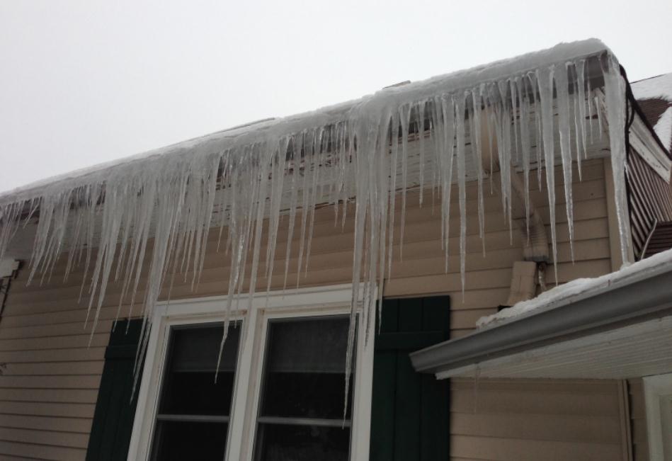
What may turn into the coldest arctic outbreak in a decade is on the way. Not a casual cold front, but at least two separate waves of "Holy Thinsulate - get me out of here!" Siberian Surges. An old fashioned cold wave spilling into mid-December.

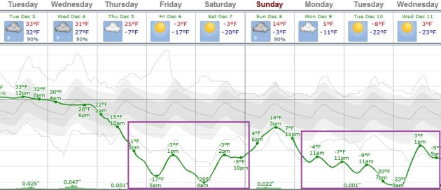
I'm predicting 5 subzero nights through the middle of next week; in spite of a Yukon-blue sky daytime "highs" may not rise above 0F on Saturday. Late week wind chills may dip to -25F or colder.
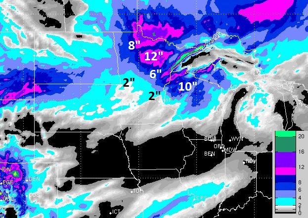
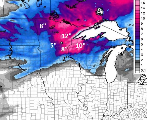
Bitter blasts are often preceded by significant snow, and we're still on track for some 4-14 inch snowfall amounts over central & northern Minnesota by Thursday; maybe 2 feet along Lake Superior's North Shore.

Today will offer a wintry mix, the rain-snow line hovering over MSP - rain and sleet mixing with wet snow at times, mainly wet roads in the metro area. As temperatures cool a changeover to snow is likely tonight, maybe 2-4" tonight into Wednesday - the best chance of 3 or 4" northern suburbs. The farther north you drive up I-35 and 371 the heavier the amounts, but enough warm air pushes north for a sloppy winter mix in the metro today. ECMWF model data still hints at a few inches of snow Wednesday in the metro.

Temperatures drop below 0F Thursday, and may stay there until Sunday afternoon - before a reinforcing blast arrives next week. Here we go!

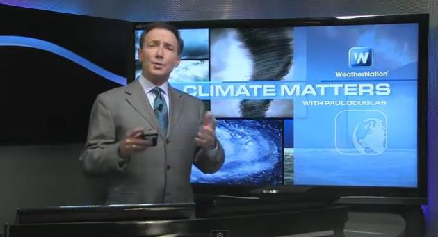
Coldest Thanksgiving In 20 Years - Here Comes The Real Deal. Last week's chill was just the appetizer; the main course comes later this week, another Yukon punch early next week. Some slight moderation is expected after December 15, but the next week to 10 days will leave no doubt in your mind that winter has arrived. We track the cold wave, and take a look back at a chilly Thanksgiving holiday, and why (many) retailers were smiling in today's edition of Climate Matters: "WeatherNationTV Chief Meteorologist Paul Douglas has a forecast for those that love winter. Brutal Arctic chills, snow, and lots of it for much of the northern tier of the United States. Also, just how does this Thanksgiving stack up against previous ones?"

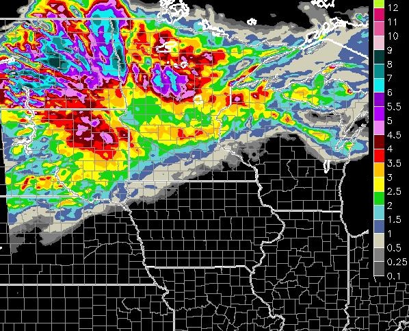
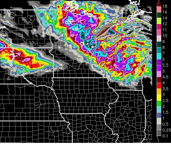
Snow By Midday Today. The HopWRF shows significant snows setting up north and east of MSP, a band of 6-9" from near Lake Mille Lacs to Cambridge, Taylors Falls to Spooner, Wisconsin by noon today.

RPM Model. WSI's 12km RPM model shows 2" of snow by Wednesday evening, with 4" far northern suburbs - closer to 8-12" from Hibbing to Duluth.

WRF Total Accumulations. A wintry mix is expected in the Twin Cities today; mainly wet, sloppy roads with surface temperatures (just) above 32F, but snow will stick 30-75 miles north/east of MSP. WRF model total accumulations suggest 1-2" south metro, but as much as 3-5" northern suburbs, most of that falling tonight into Wednesday. I suspect totals will range from 1--2" south metro to 3-4" northern suburbs, with closer to 6-8" near Princeton and Cambridge, maybe 4-7" in the St. Cloud area.
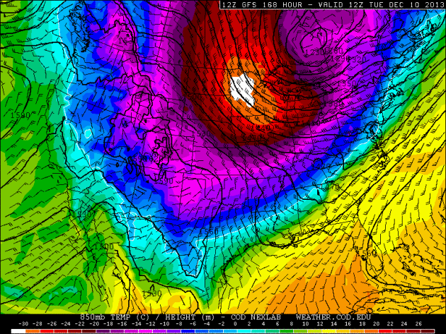
Ouch. Other, more colorful words came to mind, but ouch will suffice for now. 
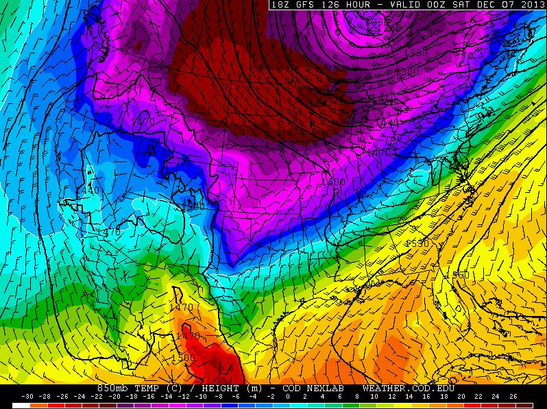
What may be one of the coldest airmasses in a decade arrives late this week, a second reinforcing smack of bitter air next week. The ECMWF (above) may be overestimating the cold a bit, but I still expect double-digit subzero lows Friday and Saturday morning, again a couple days next week. Parts of central Minnesota could easily see lows in the -20 to -30F range. I know, unreasonably cold.
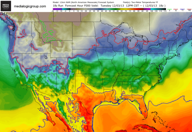
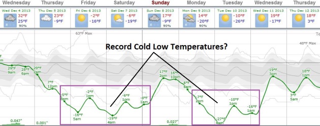
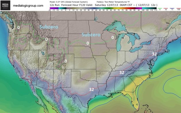
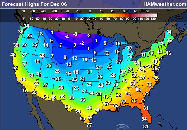
Subzero Saturday? By 6am Saturday the GFS shows the 0F isotherm near the Minnesota-Iowa border. In spite of bright sun temperatures may not climb above 0F Saturday afternoon, a rare subzero maximum at MSP. At least winds will ease by then. Chill factors Thursday and Friday may dip to -20F in the metro, -30 to -40 over parts of central and northern Minnesota. We're about to get our cold weather bragging rights back.
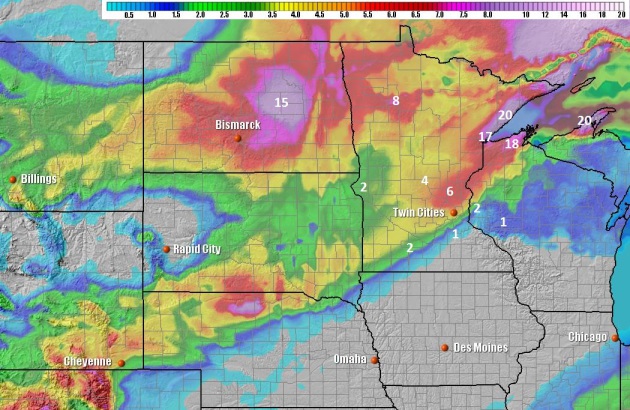
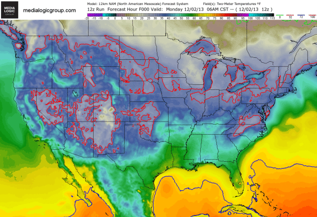
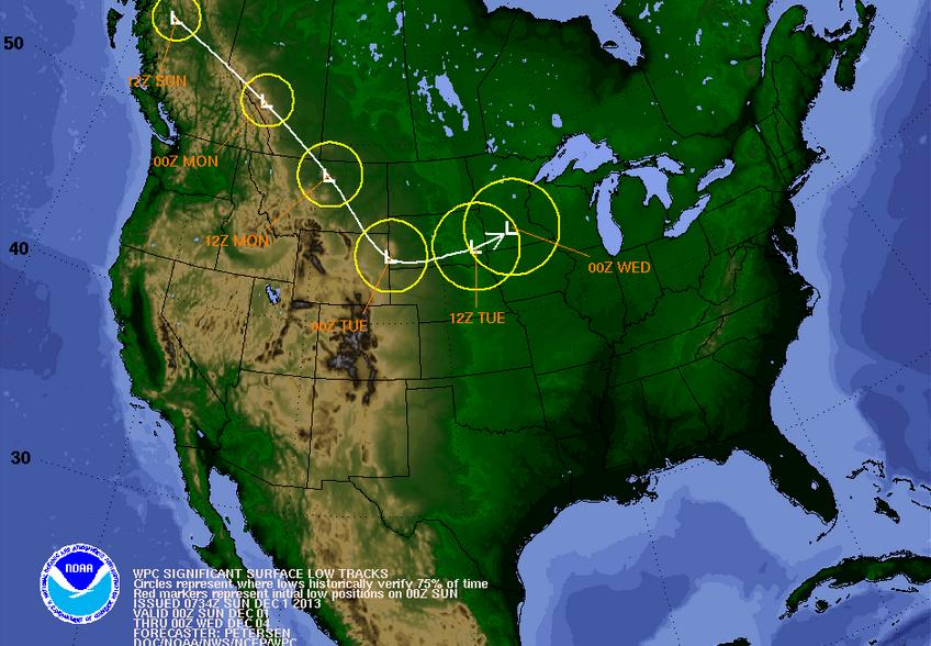
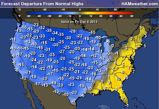
Cold Wave. Misery loves company, and as we take turns complaining about the chill, at least least the rest of America will be whining right along with us. The solid red line marks the 32F isotherm, the solid green line shows the 0F temperature sagging southward by Thursday. If you have any frequent flier miles you might want to consider cashing them in. Quickly. NAM 12km guidance courtesy of NOAA and Ham Weather.

Coldest Thanksgiving Since 1993 for USA. Here's an excerpt of a report from Planalytics - good shopping weather, it turns out: "...Overall, it was significantly colder than Thanksgiving Day last year, which was the warmest since 1998. Across the entire U.S., the 2013 Black Friday weekend (November 28 – December 1) was the coldest in 4 years. The Mid-Atlantic, New England, and East North Central regions had their coldest Black Friday weekend in over 15 years, and the South Atlantic region was coldest since 2002. New York City, Baltimore, Pittsburgh, Richmond, Charlotte, and New Orleans are just a few of the major markets which had their coldest Black Friday weekend in over 15 years. Boston was coldest since 2000, while Detroit, Cincinnati, Indianapolis, Atlanta, Nashville, and Richmond were each coldest since 2002."

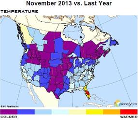
Coldest November Since 2000. Here's another timely clip from the weather analysts at Planalytics: "In the U.S., November 2013 was the coldest since 2000 and much colder than normal. Precipitation and snowfall were both greater than last year, although still below normal. Canada had its coldest November since 1996. Rain and snowfall were both greater than last year, although below normal.
  • Thanksgiving was the coldest since 1993 and driest since 2002. The Black Friday Weekend was the coldest in 4 years. Several major markets in the East had their coldest Black Friday weekend in over 15 years, including NYC, Baltimore, Charlotte, and New Orleans. Boston was coldest since 2000, Detroit and Atlanta since 2002, helping put seasonal items in customer baskets.
  • Week 4 in the U.S., which included Thanksgiving and Black Friday, was the coldest end to November in over 50 years. Canada was colder than normal..."

"...Although the first real snow of the season is [on the ground/ in the forecast], the first signs of spring are already showing up in the time of sunset. The sun is now within one minute of its earliest setting of the winter season. This will come in less than a week, on Dec. 9, when the sun will set at 4:31 PM. After that it sets later every day, reaching 4:41 PM by New Years Eve and then 5 PM by Jan. 17. It's true that the shortest day of the year is Dec. 21, but the December acceleration of the earth in its orbit around the sun distorts the time of earliest sunset back to Dec. 9. To compensate, the sun will be rising later every day until Dec. 30, when it's latest sunrise at 7:51 AM." - consulting meteorologist Dean DeHarpporte.

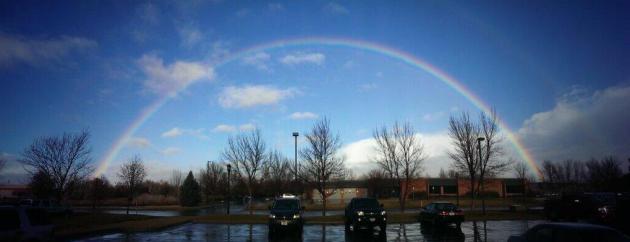
One Perfect Rainbow. Thanks to the Billings office of the National Weather Service (and Twitter) for sharing this one.

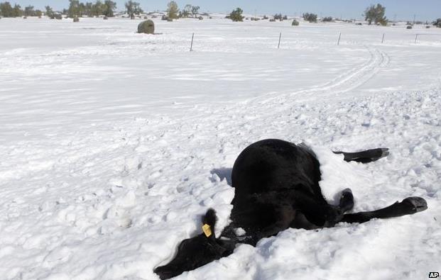
Farmers Describe "Worst Storm In 150 Years". The freakish October blizzard that hit the Black Hills of South Dakota is still making news - here's a clip from The BBC: "Nearly two months after devastating blizzards hit parts of South Dakota and Wyoming, farmers are still recovering from the loss of cattle and the effect on their businesses. The week before the storm, it had been wet and mild and the prairies of the Great Plains were deep in mud. Then, the first winter snow came early and unexpectedly in an icy blast from the north-west. Trapped in the mud, 30,000 cattle suffocated and froze to death. They were buried in 20ft (6m) snow drifts, entombed in ice in what ranchers call the "breaks and draws" - the slopes and valleys - of the rolling prairie hills..." (Photo: AP).

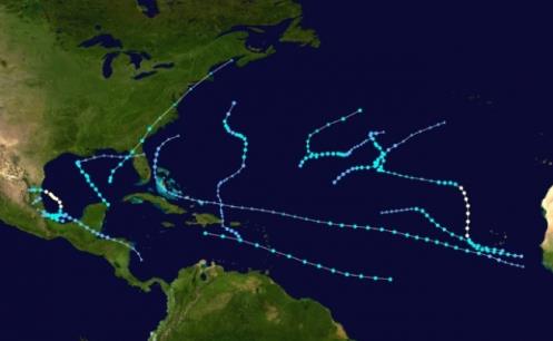
"Forecast Bust". Why 2013 Hurricane Predictions Were So Wrong. It was a season that left many tropical meteorologists scratching their heads. NPR has the audio interview; here's an excerpt: "Forecasters expected the 2013 Atlantic hurricane season to be really busy — the National Oceanic and Atmospheric Administration told Americans to expect between seven and 11 hurricanes. But this year has been one of the quietest on record. Why were the predictions so far off?"

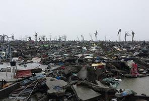
Scientists Improve Models That Can Predict Killer Cyclone Surge. Similarities between Haiyan's catastrophic storm surge in the Philippines and the killer surge that hit Galveston, Texas in 1900? Here's an excerpt of new research into storm surges at E&E Publishing: "...Tacloban's surge was possibly the highest recorded in the Philippines, rivaling the 24-foot surge record set in 1897, Needham noted. But in that surge, the researcher saw more than a record. He saw a comparison. Needham is a self-proclaimed "extreme weather" enthusiast, whose blog, Hurricane Hal's Storm Surge Blog, analyzes present and past cyclones. His ability to run down historic storm surges is similar to how a farmer can rattle off past bumper crops and famine years..."

Photo credit above: "The result of the storm surge that swept over Tacloban in the Philippines." Photo by Ton Carmello Pido Tallon.

Sydney Records Warmest Spring On Record. Weatherzone has the story - here's the introduction: "Sydney has recorded its warmest spring on record, largely due to a fiery September and October. The combined minimum and maximum for the New South Wales capital of 19.9 degrees for spring comfortably broke the previous record of 19.5 degrees set in 1988. The average maximum of 24.7 degrees smashed the previous record set in 2002 of 24.2 degrees..."

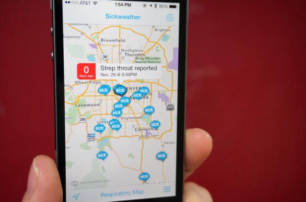
Sickweather Tracks, Then Alerts You Of Nearby Illnesses. Yes, there's even an app for that - reports of flu and other bugs surrounding your neighborhood or GPS location. CNET has more details: "...Download the free Sickweather app from the App Store, designate which viruses and conditions you want to be alerted of, and let the app do the rest. By scanning social networks for mentions of specific illnesses while filtering out redundant phrases or random uses of the word "sick" (and the like), Sickweather is able to plot where the plague has occurred on a map. When you approach an area marked on the map, you'll receive an alert of the illness and when it was last reported..."

Image credit above: Jason Cipriani/CNET.

Four Auto Features That Make Driving Easier For The Elderly. Nice photo selection for this article. Wow. What is that, a Model T? Business Insider Australia has the story - here's a clip: " Driving as a senior citizen can be hard: According to AAA, nearly 90% of drivers 65 and older suffer from health issues that affect their ability to drive safely. But as I learned when I put on a crazy suit to see what it’s like to drive as an 80-year-old man, there are lots of features that can make things easier..."

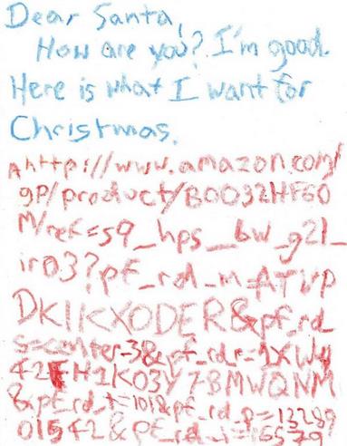
Dear Santa - Please Don't Screw Up The URL. I do this with my wife, to make sure I get the right size and color, and now kids have caught on in their pleas to Santa. Or is it a promotional device for Amazon? Details from Yahoo News.
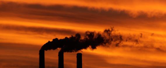

Climate Stories....
"The problem is that enough people aren’t willing to change their own behaviors or pay to support an aggressive anti-emissions program right now. That’s not simply because of oil-company lobbying. It’s because fossil fuels are cheap. They are abundant, energy-rich and easy to transport." - Editorial, Washington Post.

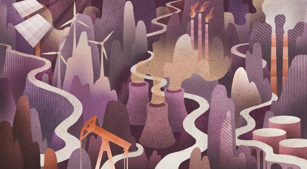
Power In 2030 - The Roads We May Take. Daniel Yergin, who has written extensively about energy and oil, has a very interesting Op-Ed in The New York Times, focused on America's energy mix going forward, a smooth transition toward less polluting and renewable fuels, or a vortex of pain? Here's an excerpt: "...How, then, to assess the energy future? One way is through the use of scenarios. These are not meant to be predictions or forecasts, but rather plausible ‘‘stories’’ about the future. They help to identify what seems to be predetermined, the things you can count on. They also highlight the driving forces and big uncertainties  —  and even the potential surprises before they occur. The scenarios below are written from the vantage point of 2030. Drawing on work that I oversaw at the research firm IHS, of which I am vice chairman, I propose three futures: ‘‘Global Redesign,’’ ‘‘Meta’’ and ‘‘Vortex.’’ Each is quite plausible but leads to very different balances between conventional energy  —  oil, natural gas and coal  —  and renewables like solar and wind..."
Image credit: Eion Ryan.

Sports Bigs Step Up On Climate Change - And They're Not Tree Huggers. Here's an excerpt of a story at The New York Daily News: "...But here was husky Craig Harnett, the NHL’s chief financial officer, talking about ponds on which many players grew up no longer freezing. “To the extent it becomes more difficult to create ice, you’re limiting access. Already in this country, there is not enough access to ice time.” He detailed league involvement with new HVAC systems in arenas and on-site renewable energy. Similarly, some MLB stadiums use solar-panel systems and wind turbines to reduce their carbon footprints. The NFL will be planting 27,000 trees, managing food recovery and taking other environmentally mindful steps in the lead up to and after February’s Super Bowl in New Jersey..."

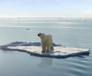
Something In The Weather Tells Us Climate Change Is Real. Yes, as I've been describing for 15 years the Symphony of Seasons is playing out of tune - the patterns have shifted. Here's a clip of an Op-Ed at The St. Louis Post Dispatch that caught my eye: "...I suspect that nearly everyone who reads this knows deep inside that something isn’t right with the weather. Science has been telling us for decades what “isn’t right.” The atmosphere has too much carbon and it’s trapping more heat, like a thicker blanket over the earth. My dad taught me something else very important and this explains why I spoke to the Environmental Protection Agency, why I give talks in the community and why I’m writing this letter. He taught me to do the right thing. It’s time for all of us “to do the right thing” and listen to what we all know deep down to be true. The evidence is overwhelming — which is why climate scientists worldwide now are 95 percent confident climate change is manmade. Not one major scientific body in the world disputes it. And don’t forget the threat the Pentagon sees..."

How Do Meteorologists Fit Into The 97% Global Warming Consensus? The author of this story at The Guardian accurately describes the vast majority of AMS members as meteorologists, not climate scientists, which is absolutely true. Here's an excerpt: "...The AMS on the other hand is not comprised primarily of climate experts. Some of its members do climate research, but only 13 percent of survey participants described climate as their field of expertise. Among those respondents with climate expertise who have published their climate research, this survey found that 93 percent agreed that humans have contributed significantly to global warming over the past 150 years (78 percent said it's mostly human-caused, 10 percent said it's equally caused by humans and natural processes, and 5 percent said the precise degree of human causation is unclear, but that humans have contributed). Just 2 percent of AMS climate experts said global warming is mostly natural, 1 percent said global warming isn't happening, and the remaining 4 percent were unsure about global warming or human causation..."

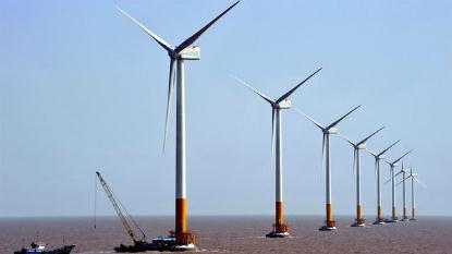
Tech Leaders, Economists Split Over Clean Energy's Prospects. Here's a clip of a story from NPR: "...Kammen thinks advances in technology are on the horizon that could push the United States rapidly away from fossil fuels. If we put a price on the environmental damage caused by carbon dioxide, clean forms of energy like solar would become comparatively cheaper, he says. That would trigger a whole new relationship between people and energy, he says, as homeowners produce power instead of simply consuming it. People would have a powerful reason to install solar panels and store some of that energy in the batteries in their electric cars — and even send short bursts of it to the power grid..."

Sunday, December 1, 2013

Meteorological Winter In Like a Lion? Arctic Blast on the Way Second Half of Week

"Our Roads Smell Like Wisconsin"
Just when you think Wisconsin couldn't get anymore Wisconsin-like... they go and through cheese
brine on their roads, but for good reason! Check out this story from ModernFarmer.com

"From backwoods county highways to Milwaukee city streets, Wisconsin road crews will be using a new weapon in the war on winter accidents — cheese brine.
Brine is a liquid cheese-making byproduct; if you’ve bought fresh mozzarella, it often comes floating in the stuff. To cheese-makers, it’s a hassle — they spend many thousands of dollars to dispose of cheese brine each year, trucking it to wastewater treatment plants.
the first year alone, tiny Polk County saved $40,000 in rock salt costs. Conversely, F&A Dairy saved on brine disposal costs — to the tune of nearly $30,000.
The odor stems from organic matter, little bits of cheese flotsam left from the brining process. It’s these bits that make brine so effective as a road de-icer. Regular salt brine has a freezing point of 6 below zero, but cheese brine doesn’t freeze up until 21 below."

Read more HERE:


Winter Weather Headlines
A cheesy road advisory? With snow on the way to parts of wisconsin, I wouldn't be surprised if there some type of smell advisory that gets issued at some point! Take a look at the winter weather headlines that heve been posted for parts of the U.S.


Tracking Our Next Winter Storm
Model runs have been fairly consistent on shovelable snow across much of the northern/central Rockies into parts of the Upper Midwest since last week. As we continue through the first half of the week, the track of the low pressure system will wobble with time. The track of this low will dictate where some of the the heaviest snow will be found through that time. According to NOAA, here's the track of the low pressure through PM Tuesday.


5 Day Precipitation Potential
According to NOAA, here' the 5 day precipitation potential across the nation. It appears that some decent accumulations of either rain or snow will be possible over the coming days as our next storm system moves through the central part of the country.


Snow Potential
Here's the latest snow potential through midweek, which shows a bunch immediately north of the international border. However, there will definitely be some plowable stuff in the Lower 48 through that time.


Plummeting Temps
Anytime temps plummet the way they look to do late this week, I am reminded of this guy. Do you know who he is?


It's Yukon Cornelius!
He's the one who helped Rudolph the Red Nosed Reindeer. His name also resembles a cold place, the Yukon and thats exactly where our weather is coming from! Take a look at temps for late week.


High Temps Friday
Here's a brief look at how cold actual daytime high temperatures could be by Friday.


Highs From Normal Friday


Badger Lake
Have you ever heard of Badger Lake? No? If not, this would be a great stocking suffer for you or someone you know this holiday season! I just received my copy this weekend and have already cracked into the 1st chapter. It was written by my good friend and colleague, Aaron Shaffer. It seems very intriguing so far AND there's even an interest to weather enthusiasts as a tornado makes an appearance into the book!

"Murder and corruption. A small-town news team. Tropical birds. Sharp-clawed badgers. A tornado. What could possibly go wrong? Badger Lake is a fun and fun-ny mystery/adventure novel, combining the never-ending surprises of Carl Hiaasen and Tim Dorsey’s humorous writing with the easy-reading and fast-paced style of Spencer Quinn’s Dog On It series. After two strange murders in two days, small-town Badger Lake needs some heroes. A twisted, but strangely comical, storyline pits small-town television news against East Coast mob. Who are the heroes trying to find a pair of bumbling murderers? A motley crew, consisting of tropical bird-toting television reporter Walt Johnson, an intern who wants to be known as "Captain," and their TV station's peculiar management team — a cross-dressing general manager and a news director with a roughly ten-second attention span. While attempting to solve the murders, the group of news men forms an alliance with a pair of well-educated, scantily-clad college women, and a lazy, but emotional, sheriff. There are painful encounters with wild animals, strange water chases involving boats and animals, a tornado, and many other scenarios that could only take place in one place: Badger Lake, Wisconsin."


Thanks for checking in and have a great week ahead!
Don't forget to follow me on Twitter @TNelsonWNTV