Friday, May 2, 2014

Fire & Ice - Most Great Lakes Ice in April since 1973


Getting Better

So it's come to this. Yesterday, when the sun finally came out in all its glory, the meteorologists I work with crept up to the Amish Doppler (window) and began clapping. Kind of sad. Moss is now forming on my north side. Daffodils coming up in the yard are doing the backstroke, but my rice paddies are coming along nicely.

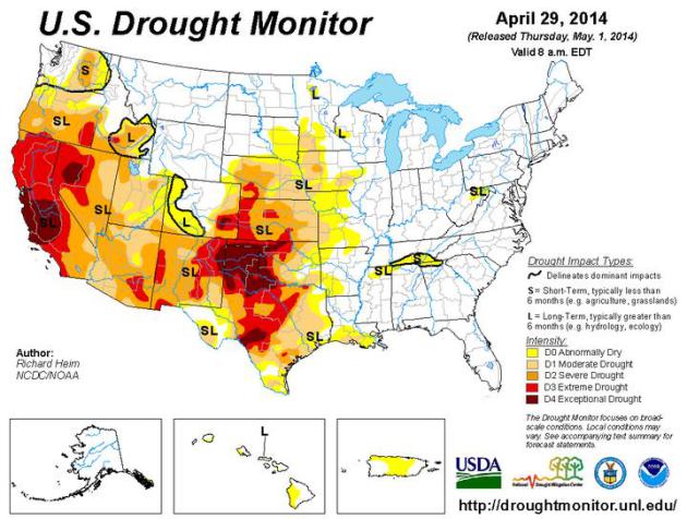
Nearly 10 inches of precipitation has fallen on MSP since January 1, 3.63 inches wetter than average. With any luck a deepening drought spreading from California to the Plains won't creep back up to our latitude.

I still see a cool bias into much of May; the core of the jet stream still 200-400 miles farther south than usual for this time of year. But we're stumbling in the right direction.

Showers sprout near Duluth later today, but much of Minnesota salvages some sun with highs near 60F. A few light showers may brush far southern Minnesota Sunday morning - heavier T-storms are brewing for the middle of next week. A few could even be severe as temperatures rise above 70F.
In today's weather blog below: CO2 levels hit a new record, the most Great Lakes ice in April since 1973 and Minnesota ice-out dates are running 8 days later than average. Never a dull moment.

Stumbling Into Spring. Expect mid to upper 50s today, but a warming trend arrives next week. Not exactly a hot front, but a spike of warmth Wednesday may spark a few strong to potentially severe thunderstorms nearby. Steadier rain gives way to clearing next Friday; ECMWF guidance suggesting more low 70s next weekend. Graphic: Weatherspark.

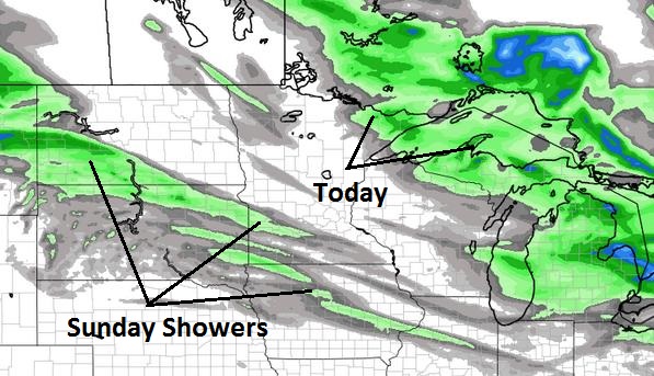
Weekend Showers. The best chance of a few instability showers today will come north and east of Duluth. A second (weak) system spreads a few light showers into southwestern Minnesota Sunday; rain will probably pass south and west of MSP with some high and mid level clouds nearby. 4 KM WRF data: NOAA and WeatherBell.

Drying Out. After this week's stalled storm and record rains from Pensacola to Tampa northward to Philadelphia and Long Island much of America dries out this weekend. Next week's northward shift of the jet stream may spark a wave of heavy showers and T-storms from the Dakotas to the Great Lakes by midweek.

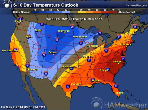
Extended Outlook: East Coast Heats Up - Cool Bias Rockies to Upper Midwest. After warming into the 60s next week, even 70s by Wednesday, temperatures cool off a bit between May 8-12 from Denver to the Twin Cities and Green Bay as the jet stream continues to bulge southward, pulling cooler air out of Canada. Map: NOAA and HAMweather.

April Weather Highlights and Low-Lights. Here's an excerpt from Dr. Mark Seeley's always-illuminating WeatherTalk newsletter: "...Cooler and wetter than normal describes the month of April in Minnesota for a second consecutive year. April of 2014 was the 6th consecutive month with cooler than normal mean monthly temperatures reported. Most observers reported mean values for April temperature that were from 4 to 6 degrees F cooler than normal. Extremes for the month ranged from 82 degrees F at Madison (Lac Qui Parle County) on April 9th to -11 degrees F at Hallock (Kittson County) on April 2nd. Only 9 days during the month brought above normal temperatures. Minnesota reported the coldest temperature in the nation on four dates during the month..."


April Climate Recap. Here are a few highlights from the most recent HydroClim Minnesota Update from the Minnesota DNR:
  • April precipitation totals were variable across Minnesota, ranging from less than two inches in southwest and north central Minnesota counties, to over six inches in east central, south central and southeast Minnesota locales. In the wetter areas, monthly precipitation totals approached or exceeded all-time record highs for the month of April.
  • Average monthly temperatures for April in Minnesota were below historical averages. It was the sixth consecutive month of below-average temperatures.
  • The U. S. Drought Monitor places portions of southwest Minnesota in the Moderate Drought category.
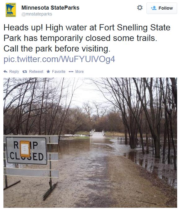
  • Stream discharge values are high to very high at most Minnesota monitoring locations. Minor flooding is occurring in some areas. Moderate flooding is underway or projected at a few locales along the Red River of the North.
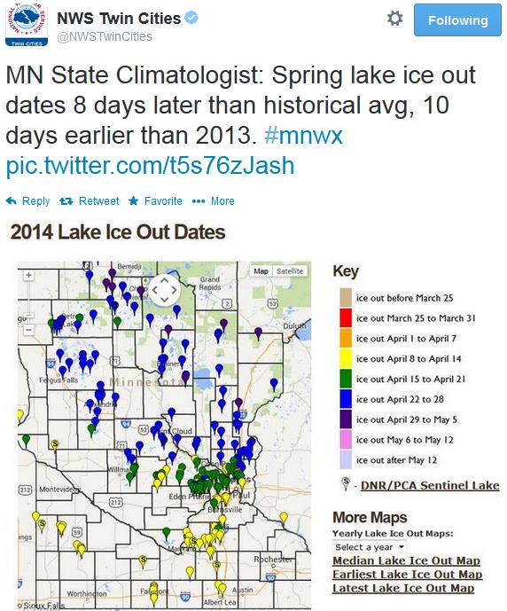
  • Most lakes in the northern one-quarter of Minnesota remain ice covered. This spring, lake ice out dates are approximately eight days later than historical median ice out dates, but 10 days earlier than in 2013

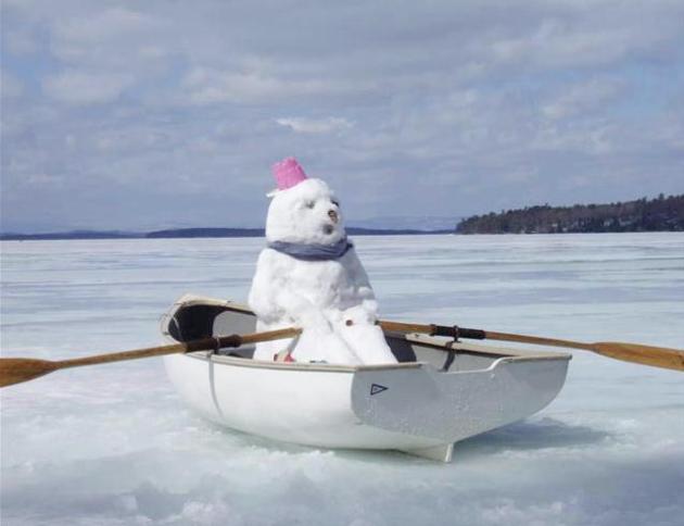
Speaking of ice....

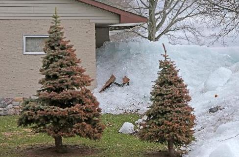
Wall of Ice Damages Homes, Threatens Resort Near Mille Lacs. It's deja vu all over again. Here's a clip from an article and video at The Star Tribune: "Driven by high winds, ice from Lake Mille Lacs has gone on a rampage in recent days, bursting into homes, tearing up the shoreline, blocking roads and forming massive mounds in yards. The problems are mostly in the Garrison, Minn., area on the western shore of the lake, which has taken the brunt of the east winds accompanying recent rains. Last year, it was the southeast corner of the lake, near Isle and Wahkon..."

Photo credit above: "Ice swept and damaged Randy Dykhoff's property along the shore north of Garrison, MN Thursday, May 1, 2014. Dykhoff, of Mound, was notified by the Sheriff's office of the damage that had occurred last Sunday. He said he carried several wheel barrow loads of ice through his kitchen. He has owned the property since 1997 and It was the first time he has experienced this." Photo: Elizabeth Flores.
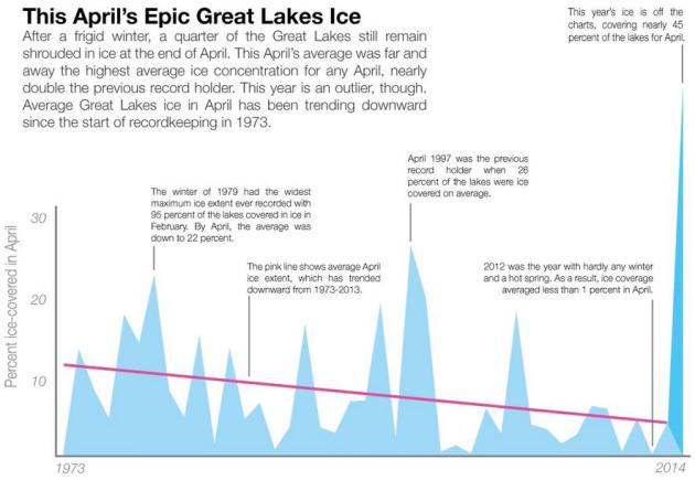

Winter Won't Let Go: Great Lakes Still On Ice. The most April ice since 1973? Climate Central has an update; here's an excerpt: "April has come and gone but a record amount of ice still remains on the Great Lakes. This April was the lakes’ iciest on record after a near-record winter, and the season has been notable for how early ice formed and how long it’s lingered. At the close of April, nearly a quarter of the five Great Lakes — the largest group of lakes on Earth — still have ice on them and ice is likely to linger for weeks to come according to the Great Lakes Environmental Research Laboratory. That makes the month far and away the iciest April since recordkeeping began in 1973..."

Image credit: Climate Central and Great Lakes Environmental Research Laboratory.
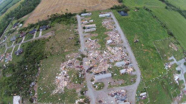
Alabama Tornado Outbreak 2014 By The Numbers: 20 Tornadoes, 153 Miles of Damage. Meteorologist Paul Gattis has a good update on the extent of damage at al.com; here's a clip: "It wasn’t the tornado outbreak of April 27, 2011. In fact, it wasn’t even close. But the storms that swept across Alabama on Monday and into early Tuesday morning was the most significant outbreak since that historic day three years ago. According to storm surveys from the National Weather Service, 20 tornadoes touched down across central and northern Alabama – including two that touched down just north of the Alabama-Tennessee state line in Lincoln County, Tenn..."

Image credit above: "Sky View HSV used a quadcopter to capture footage from storm-ravaged areas in the Bay Hill Marina, Coxey community and along 7 Mile Post Road in Limestone County Wednesday, April 30, 2014." (Contributed by Sky View HSV).
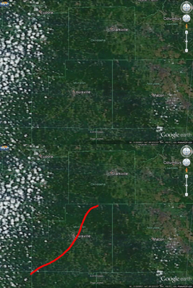
Tornadoes Carve Scars Into The Earth That Are Visible From Space. The EF-4 that hit Vilonia and Mayflower was a monster; winds may have peaked close to 200 mph. The length, width and ferocity of the tornado becomes apparent when you can see the debris field from space. The Vane and Newsweek report; here's an excerpt: "Almost three dozen people were killed in the latest tornado outbreak that tore through the Deep South this week. The outbreak included several "long-track" tornadoes, which can drag across the landscape for tens and sometimes hundreds of miles, leaving behind scars on the earth's surface that can be seen from space. Gawker's The Vane blog created gifs out of satellite images that clearly show the scars, eerie reminders of the scale of the havok the tornadoes wreaked. These scars tend to dissapear in several months as vegetation regrows, though they linger for longer in more populated regions, according to The Vane..."


Image above: The Vane.


Mamma Mia! Another Tornado Video from Italy. More tornadoes in unlikely places. Mike Smith Enterprises Blog has the video clip.


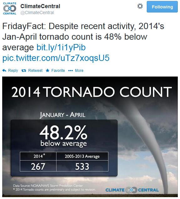
Tornadoes Most Likely To Occur During Multi-Day Spans. That was certainly the case this past week, and it's something I see all the time. Red Orbit has an interesting article; here's a clip: "...In a report published by the journal Monthly Weather Review - Jeff Trapp, a planetary sciences professor at Purdue, said a bout of 20 or greater reported tornadoes had a 74 percent chance of occurring throughout a period of tornado activity sustained for three or more days. Throughout those exact same periods, a tornado with an intensity that scored 3 or higher out of 5 on the Enhanced Fujita scale had a 60 percent chance of hitting, the report added..."
In a report published by the journal Monthly Weather ReviewJeff Trapp, a planetary sciences professor at Purdue, said a bout of 20 or greater reported tornadoes had a 74 percent chance of occurring throughout a period of tornado activity sustained for three or more days. Throughout those exact same periods, a tornado with an intensity that scored 3 or higher out of 5 on the Enhanced Fujita scale had a 60 percent chance of hitting, the report added.
“Two extreme tornado events last year led to 32 deaths, injured more than 377 and cost $2 billion in damage and inspired this study,” Trapp said in recent statement. “Unfortunately, the devastating tornadoes these past few days, tragically, seem to be bearing out the results.”

Read more at http://www.redorbit.com/news/science/1113135713/tornado-activity-over-multiple-days-050114/#cTMX1CYYq7iuhWJC.99
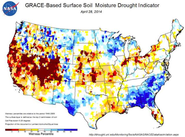
No Drought Relief In Sight For Desiccated West. Climate Central has more on a deepening drought that's spreading from California into the Plains; here's an excerpt: "...The driest places today are the places that have been dry for 2 or 3 years or longer: California, northwest Nevada and the southern Great Plains of the Texas and Oklahoma panhandles, northeast New Mexico and along the Colorado-Kansas border. In other words, drought is bringing the dust back to the Dust Bowl territory of the 1930s..."

Image credit above: U.S. Drought Portal.
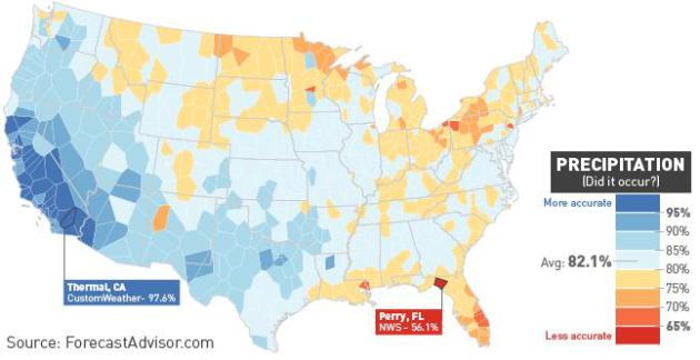
What Parts Of The Country Get The Worst Weather Predictions? One year probably doesn't "prove" anything, statistically, but every meteorologist truly does believe that their market, their city, is the hardest to predict the weather for. A friend forwarded this story along to me, courtesy of ForecastAdvisor, The Vane at Gawker. Here's a clip: "...The easiest variable to predict was precipitation, with an average of 82.1 percent accuracy. This is largely because precipitation is simplified to a "yes/no" proposition—predicting clear skies every day would net you 70 percent accuracy in many parts of the country—but also because rain and snow are also fairly predictable across large swathes of the U.S. It rarely rains in the southwest, and the outlets had the most difficulty along the Gulf Coast (where intense thunderstorms are hit-or-miss most of the year) and especially around the eastern Great Lakes, where a large portion of the yearly precipitation falls in the form of lake-effect snow..."
A Time-Lapse Of All The Earthquakes From This Record-Breaking April. I'm not a seismologist, and I don't play one on TV, but I seem to recall that tremors often come in waves, in swarms. Here's an excerpt of an interesting story at Gizmodo: "...According to the Pacific Tsunami Warning Center (PTWC) which issues alerts for tsunamis, April was a very busy month for the earth's crust. Of course there are earthquakes every hour of every day, but the world usually only seens one or two earthquakes per month that are 6.5 magnitude or higher. This April there were 13, including five that were higher than 7.8, prompting tsunami warnings. "Easily a record for this institution," reports PTWC..."

Sooo...Our Nuclear Missiles Are Run By Computers That Still Use 8-Inch Floppy Disks? This story gave me a warm and fuzzy. But are we communicating between silos with CB radio? CBS News and Huffington Post Tech have the video and story; here's an excerpt: "Contrary to what cartoons may have you believe, there’s no giant red button that detonates America’s land-based nuclear missiles. They’re actually operated by -- wait for it -- old-school computers that run 8-inch floppy disks. On a recent tour of one of the nation’s Air Force nuclear missile facilities in Wyoming, Leslie Stahl of CBS' "60 Minutes" made the surprising discovery about the archaic state of technology inside the facilities. Dana Meyers, a 23-year-old missileer working at the facility, told Stahl of the floppy disks: "I had never seen one of these until I got down in missiles..."

Twitter Is Not Dying. As a retort to a recent article at The Atlantic, Slate makes the case that Twitter is a different creature altogether, and should be judged accordingly. Here's an excerpt: "...But Wall Street—along with everyone else who’s down on Twitter because it has “a growth problem”—is making a mistake by comparing it to Facebook. Twitter is not a social network. Not primarily, anyway. It’s better described as a social media platform, with the emphasis on “media platform.” And media platforms should not be judged by the same metrics as social networks..."


Tweet above: @TheEllenShow.


Former FCC Head Michael Power Talks Future Of Cable. Listen to an interesting perspective on bundling, ala carte options and network neutrality at marketplace.org; here's a clip: "Big cable companies continue to just get bigger. In response to Comcast and Time Warner's merger earlier this year, AT&T and DirecTV are thinking of doing the same. Which got former FCC chairman Michael Powell thinking: Why are all these mergers happening? "One of the things I think is a serious issue is that the economy has been strained," he said. "I think the model has to find a way to find more affordable, more accessible packages, given the strains of the economy..."

New Smart Bike Offers Turn By Turn Navigation. Soon your bicycle will be smarter than you are. Sorry, that sounded harsh, but amazing new tech is showing up (everywhere). Gizmag reports: "...Vanhawks is hoping to get enough Valours on the road to form a mesh network of users. Through this online community, users will be able to tap into data on potholes, closed roads, blocked lanes collected by other Valours to choose safer and smarter routes. In addition, if one's Valour is stolen and another user happens to pass it by, a notification is sent via the application to alert the original owner of its whereabouts...."


Teenager Takes His Great-Grandmother To The Prom. Here's an excerpt of a heart-warming story, courtesy of FOX News: "A few months back, Delores received a telephone call from her great-grandson. Austin is 19-years-old, a senior at Parkway High School in Rockford, Ohio. And he had a very important question for his “Granny DD.” “I asked her if she would be my prom date,” Austin told me. “How cool would it be to take my great-grandmother to prom?

Lost In Translation: A "Poo Poo Smoothie"? It's not as bad as it sounds at first blush, reports The Wall Street Journal; here's a clip: "It takes a taste test to know that Burger King’s latest drink is nothing like what it sounds like. Recently, the global food chain (motto: Taste is King) began marketing a new drink to Chinese consumers called the “PooPoo Smoothie.” The name is meant to be playful, as the smoothie is actually mango-flavored. When the Wall Street Journal went to try the drink at a branch on Shanghai’s Yuyuan Road, a server behind the counter explained that the drink’s name sounds phonetically similar to the Mandarin term for bubbles, or paopao..."

Photo credit above: Laurie Burkitt/The Wall Street Journal.


Climate Stories....
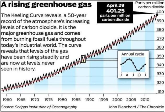
High Carbon Dioxide Levels Set a Record. SFGate has an update; here's a clip: "...The instruments that have been measuring carbon dioxide for more than 50 years showed that for the entire month of April, levels of the gas exceeded 400 parts per million for the first time, said Pieter Tans, a climate scientist at the National Oceanic and Atmospheric Agency who monitors the instrument record. The precise average for the entire month was 401.25 parts per million as of Tuesday, he said, and that level had only reached the crucial 400 threshold for the first time during a single day a year ago before dipping slightly..."

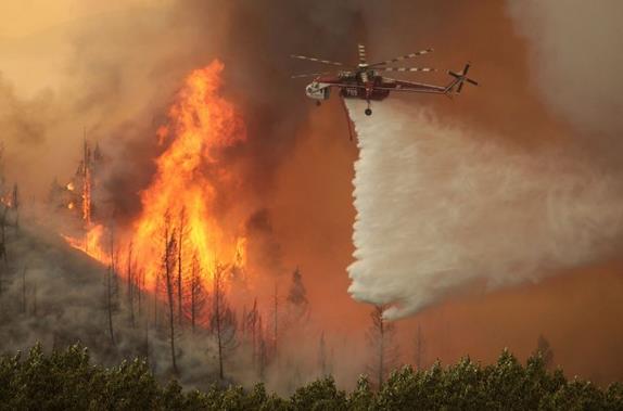
Feds: Wildfire Season Is Expected To Go Way Over Budget, And Climate Change Is To Blame. It's going to be a long, potentially record-setting fire season for much of the western USA, especially California. Here's an excerpt of a story at Salon: "...With climate change contributing to longer and more intense wildfire seasons, the dangers and costs of fighting those fires increase substantially,” Rhea said. The report notes that fire seasons have gotten 60-80 days longer over the last three decades, and that annual acreages burned have more than doubled. One way or another, the fires are going to be fought — it’s not really a problem anyone’s able to ignore. But the agencies are pushing for a change to the way we fund their efforts: bipartisan legislation recently introduced in Congress, and backed by Obama, would treat the worst wildfires as natural disasters, like hurricanes, qualifying them for special relief funds not subject to budget caps."

Photo credit above: "This Aug. 16, 2013 file photo shows helicopters battling the 64,000 acre Beaver Creek Fire north of Hailey, Idaho." (AP Photo/Times-News, Ashley Smith, File).
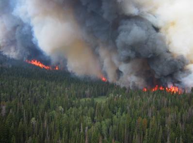
This Year's Wildfires Could Incinerate The Nation's Fire Budget. Here's a clip from The Center for Investigative Reporting: "...The upcoming wildfire season could cost $400 million more to fight than the Forest Service and Interior Department have in their available budgets, according to a report those agencies released today. The forecast estimates that the Forest Service and Interior will need to spend a combined total of about $1.8 billion fighting wildfires this year (though the actual amount could be significantly higher or lower), while only $1.4 billion is available for that activity..." (File image: EPA).

As Wildfire Fear Rises, U.S. Tanker Fleet Incomplete. The Washington Post reports.

How To Convince Conservative Christians That Global Warming Is Real. Mother Jones has the story of Dr. Katharine Hayhoe, a conservative, right-leaning, Evangelical Christian. Who also happens to be one of the world's leading climate scientists. Here's an excerpt: "...Why is Hayhoe in the spotlight? Simply put, millions of Americans are evangelical Christians, and their belief in the science of global warming is well below the national average. And if anyone has a chance of reaching this vast and important audience, Hayhoe does. "I feel like the conservative community, the evangelical community, and many other Christian communities, I feel like we have been lied to," explains Hayhoe on the latest episode of the Inquiring Minds podcast. "We have been given information about climate change that is not true. We have been told that it is incompatible with our values, whereas in fact it's entirely compatible with conservative and with Christian values..."

Image credit: Katharine Hayhoe.
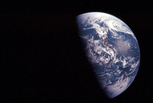
Why Doesn't Anyone Know How To Talk About Global Warming? Smithsonian Magazine poses the question; here's the introduction to their story: "When Vox.com launched last month, the site's editor-in-chief, Ezra Klein, had a sobering message for us all: more information doesn't lead to better understanding. Looking at research conducted by a Yale law professor, Klein argued that when we believe in something, we filter information in a way that affirms our already-held beliefs. "More information...doesn't help skeptics discover the best evidence," he wrote. "Instead, it sends them searching for evidence that seems to prove them right..." (Image above: NASA).

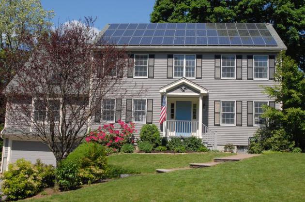
Solar Comes of Age. Here's an excerpt of an Op-Ed from Mark Andrew at The Star Tribune: "...Solar energy enjoyed a surge last year never before seen. 2013 global installations was over a third of all solar installed before it; in the U.S. new solar spiked to 10 gigawatts, an increase of over one-third in a single year. That translates to something like 1.6 million American households being powered by solar today. I was astonished to learn that the Minnesota Public Utilities Commission recently granted approval of 150MW of new electrical capacity by choosing a solar project over natural gas based largely on economics. "This is the first time solar has competed favorably with coal or natural gas in a head-to-head economic competition and won", said Michael Krause, a national authority on clean energy and green roofs and Founder of the Minneapolis-based Green Institute. "Solar is coming into its own as a key source of our state's energy portfolio"... (File image above: Wikipedia).

Thursday, May 1, 2014

A Week of Jaw-Dropping Weather Extremes


May-bruary

When weather stalls bad things can happen. That was certainly the case this week: biggest tornado outbreak of the year so far (EF-4 strength in Arkansas), biblical 26-inch rains near Pensacola and raging wildfires outside Los Angeles.

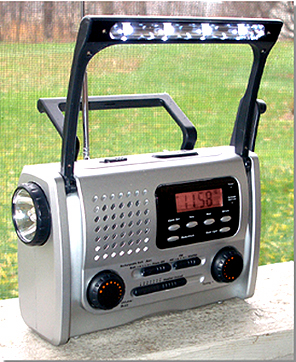
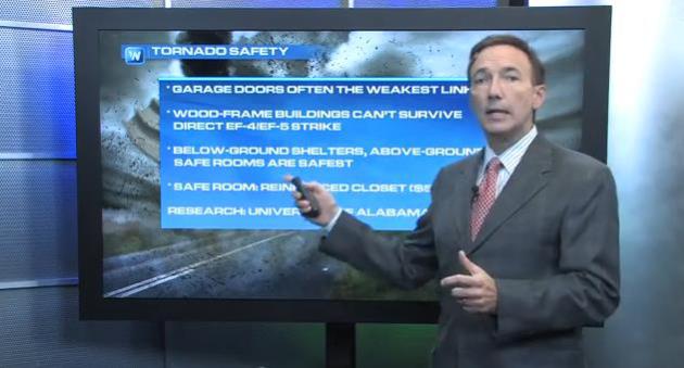
A few take-aways from the latest tornado swarm. 1). Most of us are drowning in data, but NOAA Weather Radio is still the most effective way to get life-saving warnings, especially at night, when tornadoes produce a disproportionate number of deaths. 2). Research at the University of Alabama suggests that garage doors are often the weakest link in the chain. Once the garage doors come off the combination of wind & pressure can tear away at a home's structure. If you don't have a basement consider skipping a family vacation and reinforcing a closet to be a "safe room". You may thank yourself down the road.

A weak clipper sparks a few showers today - but the weekend looks dry with 50s and a ration of desperately needed sun. Sunday showers may brush southern Minnesota.

No hot fronts are imminent but we'll see 60s, even 70F by the middle of next week, with a few scattered T-storms. April was 5F cooler than average.

Welcome to the (very) reluctant spring of '14.

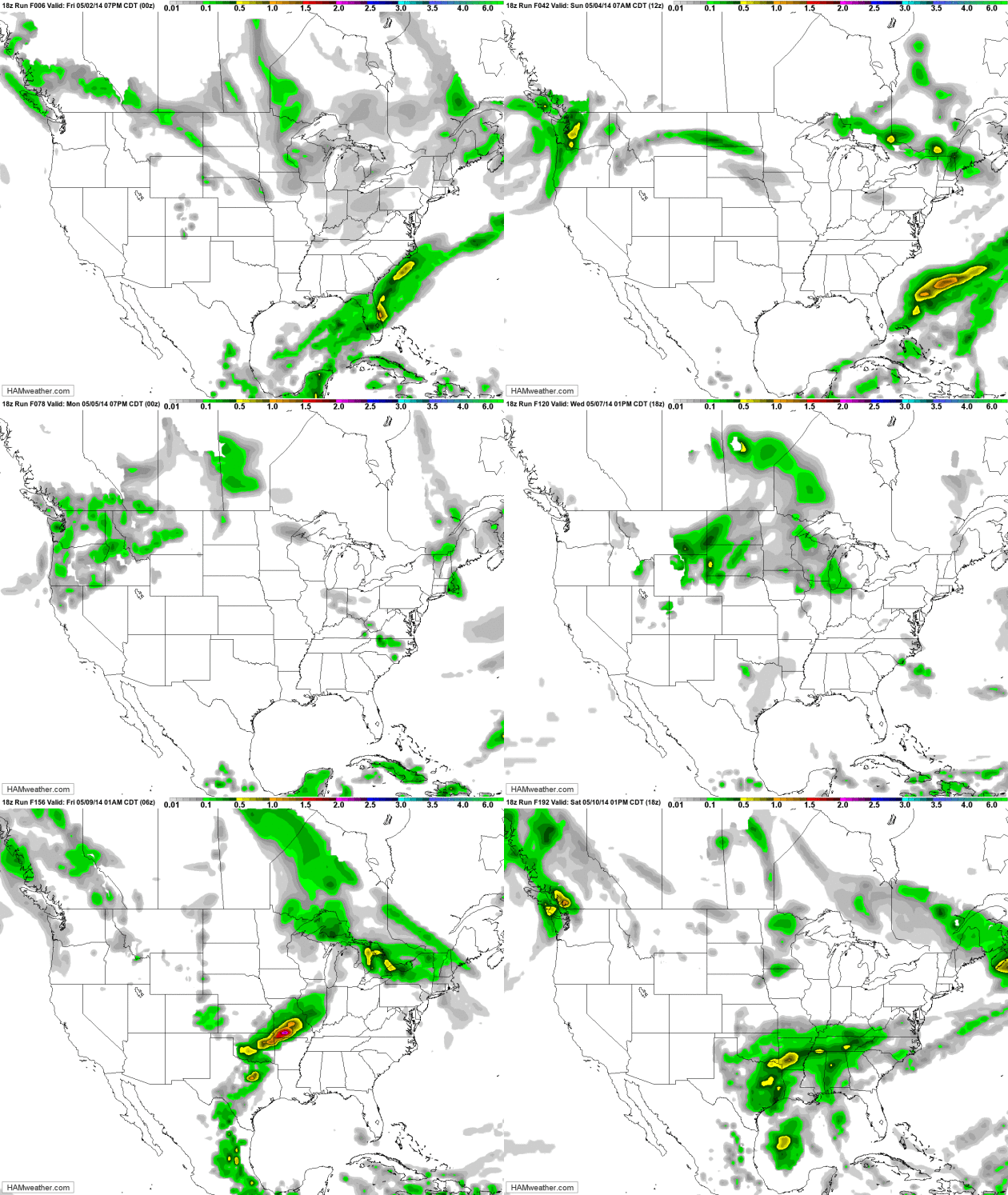
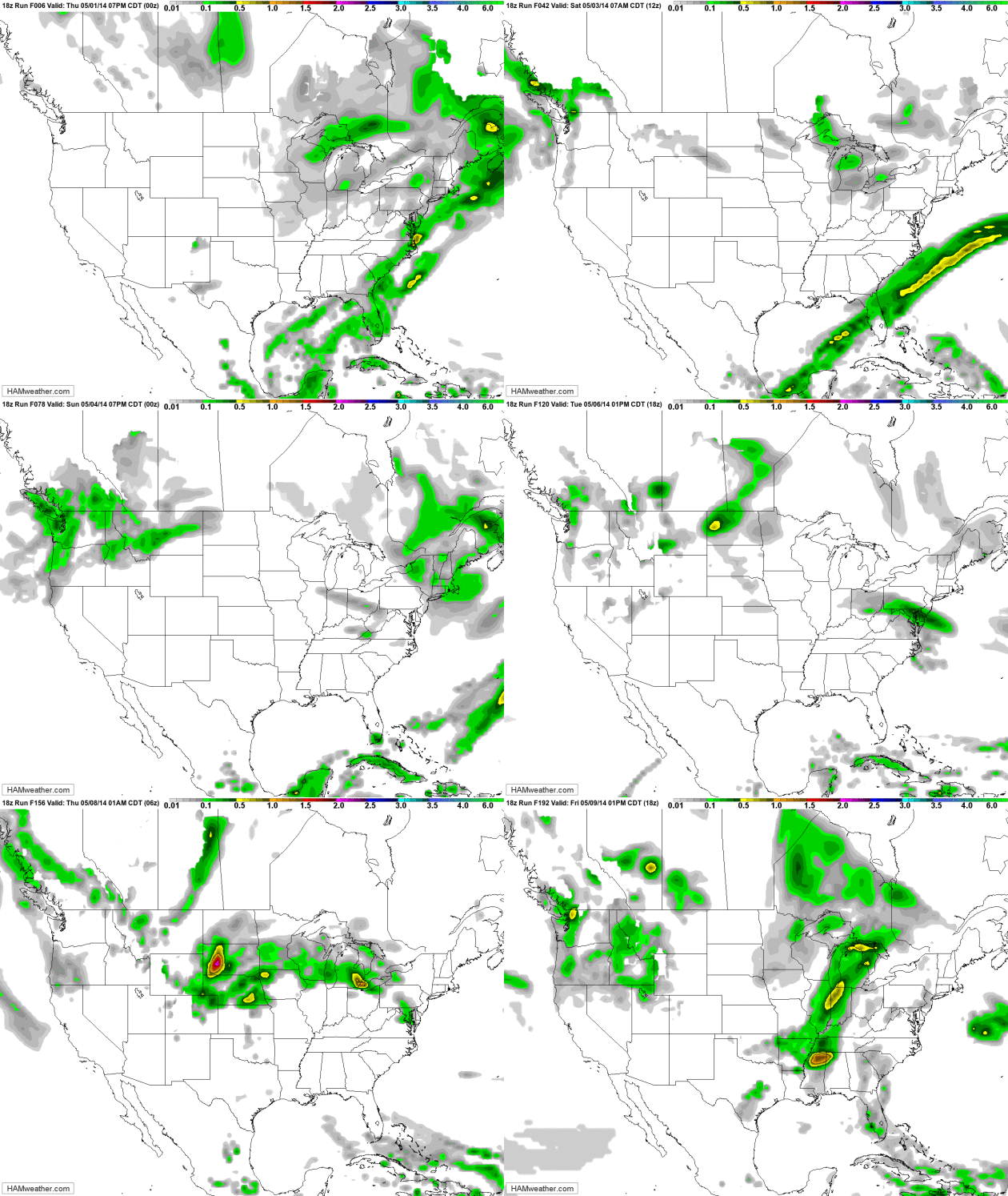
Easing Back into Spring. The jet stream lifts north next week, pushing strong to potentially severe storms into the Upper Midwest by the middle of next week. California remains dry; heavy showers pushing north across the Pacific Northwest. GFS Outlook: NOAA and HAMweather.

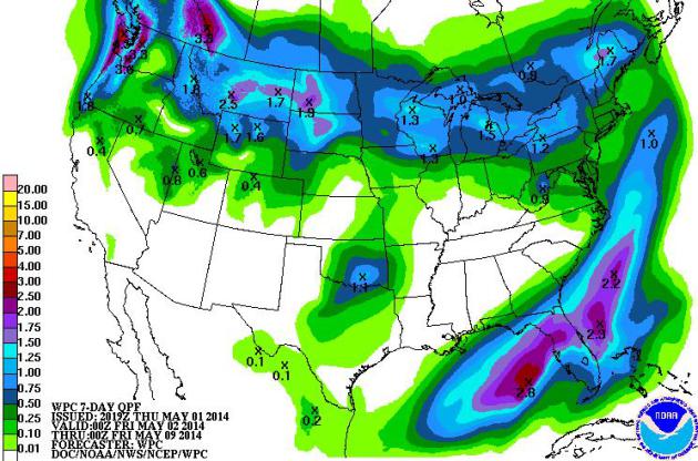
7-Day Rainfall Outlook. NOAA ensemble models shows some 1-2" rains for parts of Florida (including hard-hit counties in the Panhandle), and from Seattle to Bismarck, Madison, Flint and Rochester New York by Friday of next week.

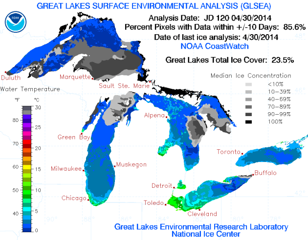
Great Lakes Ice Cover. There may still be ice on stretches of Lake Superior in early June at the rate we're going. As of April 30, 2014 23.5% of the Great Lakes were still covered in ice. Source: NOAA GLERL.

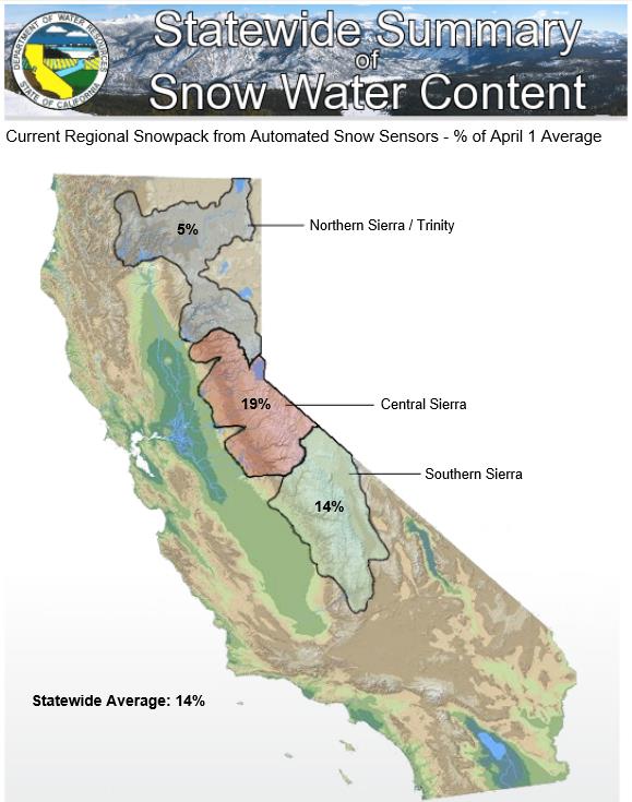
A Discouraging Snowpack Update for California. There won't be much water to replenish low reservoirs in California this year, based on the latest findings from the California Department of Water Resources; here's an excerpt: "Anyone who doesn't think conservation is important should drive up the hill and take a look," said DWR Director Mark Cowin. "Coupled with half our normal rainfall and low reservoir storage, our practically nonexistent snowpack reinforces the message that we need to save every drop we can just to meet basic needs." More dramatically, today's electronic readings shows a dismal 7% of average water content in the northern Sierra snowpack that helps fill the state's major reservoirs which currently are only half full..." (Image above courtesy of Pacific Institute).

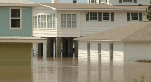
"Worse Than Hurricane Ivan". Hundreds Rescued From Gulf Coast Floodwaters. Pensacola picked up 15.55" of rain on Tuesday, a new 24-hour rainfall record. To put that into perspective Los Angeles has seen 15.9" of rain since January 1, 2012! Here's an excerpt from nola.com: "...In Gulf Shores, Ala., where nearly 21 inches of rain fell over a day's time, the scene resembled the aftermath of a hurricane. At the Sportsman Marina in Orange Beach, employee J.J. Andrews couldn't believe what she saw out the window. "We've got water up in our parking lots," she said. "Our docks are under water. It's worse than during Hurricane Ivan, is what they're saying. It's crazy." The 2004 hurricane dumped 3 to 7 inches of rain along the Florida Panhandle..."

Photo credit above: "In Foley, Alabama, some people couldn't get out of their homes on Wednesday, April 30, 2014, after flood waters surrounded their homes, many of which are built on stilts. The National Weather Service says the Fish River peaked at a record high level of 23.18 feet after more than 22 inches of rain fell in the area over two days. Some residents said the flooding was the worst they had ever seen." (AP Photo/Alex Sanz).

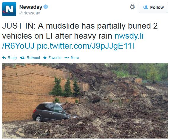
Long Island Mudslides. Photo and tweet above courtesy of Newsday.
Rainfall Reports:

6.06" Unionside, NJ
5.98" 5 miles SW of Queens, NY (NYC)
5.82" Roslyn Heights, NY
5.72" Midwood, Brooklyn (NYC)
5.12" Central Park (NYC)
Also: Baltimore, MD finished 0.1" shy of a new record for an April rainfall record.
BWI Airport: 8.60" of rain in April; Record (1889): 8.70" Wednesday's 3.06" of rain at BWI airport tied a daily record (1947).

* data courtesy of Chris Bianchi at WeatherNation.

Arkansas Tornado Rated EF-4. That's about as powerful as they get, capable of scraping even well-built homes down to foundation. Here's an excerpt from baxterbulletin.com: "...The scene was chaotic after Sunday’s storm: scraps of metal wrapped around tree limbs, brick homes reduced to rubble, bark stripped from trees. Tractor-trailers and heavy-duty SUVs were flipped over and flung like toy cars. The nation hasn’t had an EF5 storm since last May, when Moore, Okla., was hit by a twister that killed 24 and destroyed 1,000 homes. There have been only 59 EF5 storms since modern record-keeping began in 1950. Some residents in the hard-hit communities of Vilonia and Mayflower described hearing the storm, comparing it with the roar of a freight train or jet engine. Mayflower Mayor Randy Holland described it as “the loudest grinding noise I’ve ever heard...”

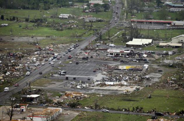
Photo credit above: "This Monday, April 28, 2014 aerial photo shows destroyed buildings and debris along U.S. Highway 64 in Vilonia, Arkansas. Vilonia was hit hard Sunday for the second time in three years. Four people were killed in a 2011 storm. Until this late April 2014 outbreak, the U.S. as a whole had by far the quietest start of the year for tornadoes. Longer trends show more tornado clusters recently." (AP Photo/Danny Johnston).

Truck Carried 27 Miles By Arkansas EF-4 Tornado. When I first saw this headline I thought "that can't possibly be true". But then I thought about the sustained updraft in a (confirmed) EF-4 with 180 mph. winds and I guess it's not beyond the realm of possibility. Here's a clip from USA Today: "A truck was reportedly carried 27 miles by a tornado Sunday night in Arkansas, according to meteorologist Darby Bybee of KHBS-TV in Fort Smith. Bybee reported that the truck was carried from Mayflower, Ark., to near Vilonia, Ark., a distance of about 27 miles. A report from the National Weather Service in Little Rock notes that an EF-4 tornado -- with winds of at least 180 mph -- traveled 41 miles on a path that included both Mayflower and Vilonia. The tornado killed 15 people..."

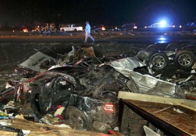
Photo credit above: "In this Sunday, April 27, 2014 photo, a person walks past cars strewn across Interstate 40 when a tornado struck the town of Mayflower, Ark. A tornado system ripped through several states in the central U.S. and left more than a dozen dead in a violent start to this year's storm season, officials said." (AP Photo/The Arkansas Democrat-Gazette, Benjamin Krain).

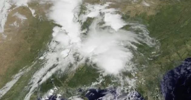
GOES Animation Of The April 27-28 Tornado Outbreak. You can see the supercell thunderstorms mushrooming to life, courtesy of NOAA and NASA: "This animation of NOAA's GOES-East satellite data shows the development and movement of the weather system that spawned tornadoes affecting seven central and southern U.S. states on April 27-28, 2014." Credit: NASA/NOAA GOES Project.

* more details on using weather satellites to track tornadic storms from Space Daily.

Tornadoes, Dust Storms and Floods. What The Hell Happened This Week? There's a compelling body of scientific data that rapid warming of the arctic may be slowing jet stream winds at northern latitudes, creating more blocking patterns, more "closed lows" (sometimes called cut-off lows) that stall for days at a time. As I've said repeatedly (ad nauseum) over the years, when weather stalls bad things can happen. Meteorologist Andrew Freedman has a good explainer at Mashable; here's an excerpt: "...Blocking patterns such as this one often lead to extreme weather events, especially temperature and precipitation extremes. For example, a blocking pattern across Europe and Russia in 2010 led to the deadly Russian heat wave that killed thousands and contributed to massive wildfires, as well as the disastrous Pakistan floods that occurred around the same time. Another blocking pattern resulted in the deadly 2003 European heat wave, which killed an estimated 40,000 people..." (graphic above: Mashable).

How Can We Make Homes Safer From Tornadoes? Keying in on recent research from the University of Alabama, I take a look a structural steps we can all take to lower the risk of tornado-related damage. Step 1: reinforce your garage doors. That's the subject of today's Climate Matters.

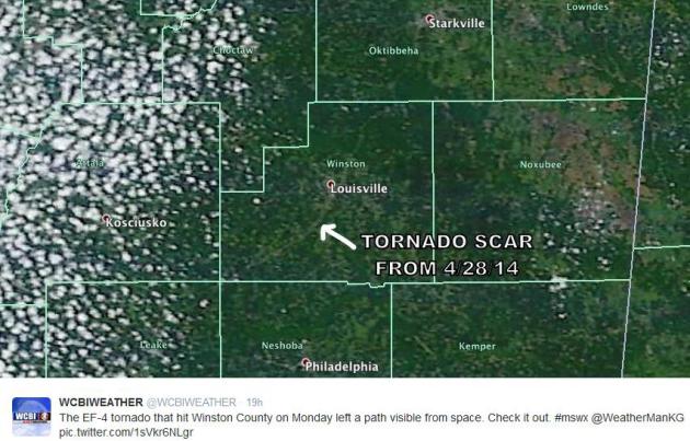
Tornado "Scar". You know it's a bad tornado when you can see the debris path from low Earth orbit. Here's an image passed along by WCBI-TV of the EF-4 tornado that smashed into Louisville, Mississippi on Wednesday.

Tornado Survivors Install Safe Rooms. If you live in or near Tornado Alley, or Dixie Alley in the south, or Hoosier Alley in the Ohio Valley, consider skipping 1 family vacation and putting that money into a safe room. You may thank yourself down the road. Here's a clip from a story at the Pekin Daily Times in Pekin, Illinois: "...Both families are staying put, rebuilding their homes as the same locations. This time, each home will have a concrete safe room, complete with a steel door, in the basement. Their builders recommended adding a safe room when asked about it. The Bowers inspected a safe room at a home in rural Washington before making their decision. Neither couple could give an exact figure of how much their safe room will cost, but they said it will be in the hundreds, not thousands, of dollars..."

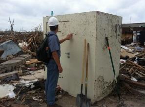
Small Changes Could Save Structures, Lives During Tornadoes, Reports UA-Involved Study. The University of Alabama has the details; here's an excerpt: "Surviving a tornado in a wood-frame residential home is enhanced by an intact roof and standing walls, but light-weight garage doors can be the weak link to allowing high winds and pressure changes into a home that can lead to the removal of the roof and collapsed walls, according to a study of damage left behind by a powerful tornado in Moore, Oklahoma, in 2013 by researchers from The University of Alabama and other institutions. “Once the roof over the garage is blown off, there usually is a significant hole into the main portion of the house,” said Dr. Andrew J. Graettinger, associate professor of civil, construction and environmental engineering and lead author of a report by a team of researchers..."

Photo credit above: "Dr. Andrew Graettinger, a University of Alabama researcher, examines a safe room that survived the tornado that struck Moore, Oklahoma, in May 2013."

Origin Of "Tornado Emergencies". KOCO-TV in Oklahoma City just ran a story explaining the origin of the term Tornado Emergency, which implies a large, deadly, confirmed tornado on the ground, moving into a more populated urban area. Here's an excerpt: "It all started with the National Weather Service in Norman. As the meteorologists watched a large, violent tornado moving into town, they asked themselves if they were doing all they could to get the message out. Tornado warnings were common. But the term tornado warning is somewhat vague. Is it doppler radar indicated? Is it a small tornado? Is it a large tornado? The truth is it could be any. But on May 3, 1999 we weren't dealing with just any old tornado warning. We had a monster on our hands. And thus the need was there to hit the message as hard as possible. And so at 6:57pm, a meteorologist in Norman added the word "emergency" to this warning..."

38% of Lower 48 States in Moderate to Severe Drought. Here is the latest interactive update from the U.S. Drought Monitor.

3 Month Drought Progression. Here's another perspective on the drought, showing how conditions have changed since early February. Much of the Midwest has seen a rapid improvement in the long-term drought,  especially in the last week with some 3-5" rains. The Pacific Northwest is also in better shape than it was during the late winter months. But drought has intensified over the central and southern Plains and much of the Southwest. Source: U.S. Drought Monitor.

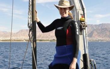
"There Will Be A Tsunami - The Question Is When" Underwater quakes can trigger tsunamis, so can underwater landslides. Israel has a history of tsunamis (which was news to me). Here's a clip from The Jerusalem Post: "...While earthquakes stronger than 7.5-magnitude have the potential to cause tsunamis, they can also be caused by underwater landslides, Goodman explained. The last tsunami recorded off Israel’s shores occurred in 1956, as a result of a large earthquake in Greek waters, she said. The last tsunami to cause any damage in Israel happened in the 19th century near Acre, she added. Caesarea most recently received a small tsunami in the 12th century, according to Goodman..."

Photo credit above: "Dr. Beverly Goodman conducts research in the Mediterranean Sea." Photo: MGM LABORATORY.

A Eulogy For Twitter. I really like Twitter, and derive a fair amount of value from the information streams and people/organizations I follow. It's often the fastest way to get information, although accuracy sometimes suffers as a result. Personally I hope it survives and thrives for the long haul, but the folks at The Atlantic are noticing some disturbing trends; here's an excerpt: "We've been trying to figure out the moment Twitter turned, retracing tweets to see whether there was something specific that soured the platform. Something is wrong on Twitter. And people are noticing.  Or, at least, the kind of people we hang around with on Twitter are noticing. And it's maybe not a very important demographic, this very weird and specific kind of user: audience-obsessed, curious, newsy. Twitter's earnings last quarter, after all, were an improvement on the period before, and it added 14 million new users for a total of 255 million. The thing is: Its users are less active than they once were. Twitter says these changes reflect a more streamlined experience, but we have a different theory: Twitter is entering its twilight..."

Image credit above: Matthias Töpfer/flickr.

Foods To Help You Age Better. Are Oreos part of a healthy Mediterranean diet? Still checking on that. In the meantime here's an excerpt of a story at PBS Next Avenue: "But it’s a 2014 study that could tie it all together into one healthy diet plan. As part of a five-year diet intervention, Spanish researchers asked overweight older adults (aged 55 to 80) to follow a healthy Mediterranean diet — whole grains, lots of produce, healthy fats, like olive oil — and then followed measures of obesity: waist size, body mass index, waist to height ratio. At the end of five years, participants showed improvements in obesity parameters and in telomere length..."

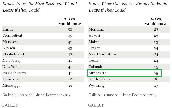
Half The People In Illinois and Connecticut Want To Move Elsewhere. Hey, it's only 1 out of 4 here in Minnesota, but the poll was taken before the Winter of Our Discontent, before the toughest winter in 30 years. I wonder what the number would be today? Here's a clip from Gallup: "Every state has at least some residents who are looking for greener pastures, but nowhere is the desire to move more prevalent than in Illinois and Connecticut. In both of these states, about half of residents say that if given the chance to move to a different state, they would like to do so. Maryland is a close third, at 47%. By contrast, in Montana, Hawaii, and Maine, just 23% say they would like to relocate. Nearly as few -- 24% -- feel this way in Oregon, New Hampshire, and Texas..."

"Wireless Underwear" - Because A Guy Just Can't Be Too Safe. If you're concerned about the RF signals coming out of that smart phone nestled in your pocket, consider this new invention, designed to protect your valuables. Gizmag has details: "Although there is yet to be conclusive evidence that radiation emitted by mobile phones and other wireless devices is damaging to male fertility, some studies have shown at least a potential link. This is why the makers of Wireless Armour have stepped in to try and provide some protection with nothing less than underwear that encases your nether regions in a Faraday cage..."


Climate Stories....

- From Gavin Schmidt's TED Talk. Details below.

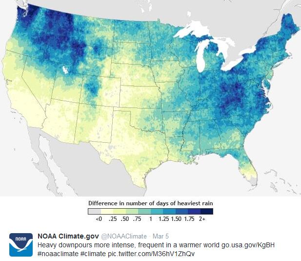
Heavy Downpours More Intense, Frequent In A Warmer World. Tell that to residents of Pensacola...or Boulder...or Calgary...or Nashville. Four thousand-year floods in Minnesota since 2004, according to the local climate office. Here's an excerpt from NOAA's climate.gov: "According to the 2009 National Climate Assessment, heavy downpours have increased in frequency and intensity during the last 50 years. Models predict that downpours will become still more more frequent and intense as greenhouse gas emissions and the planet’s temperature continue to rise. The map (above) shows predicted changes in the annual number of days of extreme rainfall (defined as rainfall totals in excess of the historic 98th percentile) across the United States by 2041-2070 as compared to 1971-2000 if greenhouse gases continue to increase at a high rate (A2 scenario). By mid-century, some places could experience two or more additional days per year on which the rainfall totals exceed the heaviest rains historically experienced in the area..."

The Emergent Patterns of Climate Change. The complexities, interactions and orders of magnitude when dealing with the Earth's climate system are staggering. Here is a link to an excellent primer, a TED Talk on climate models and detecting signals amidst the noise of everyday weather, courtesy of climate scientist Gavin Schmidt: "You can't understand climate change in pieces, says climate scientist Gavin Schmidt. It's the whole, or it's nothing. In this illuminating talk, he explains how he studies the big picture of climate change with mesmerizing models that illustrate the endlessly complex interactions of small-scale environmental events."

U.S. Corn Yields Are Increasingly Vulnerable To Hot, Dry Weather, Stanford Research Shows. Here's a clip from Stanford: "Corn yields in the central United States have become more sensitive to drought conditions in the past two decades, according to Stanford research. The study, which appears in the journal Science, was led by Stanford's David Lobell, associate professor of environmental Earth system science and associate director of the Center on Food Security and the Environment. "The Corn Belt is phenomenally productive," Lobell said, referring to the region of Midwestern states where much of the country's corn is grown. "But in the past two decades we saw very small yield gains in non-irrigated corn under the hottest conditions. This suggests farmers may be pushing the limits of what's possible under these conditions..."

The Right Lessons From Chernobyl. Clean, renewable power is the long-term answer, but in the short term solar, wind, geothermal, tides, etc won't be able to provide the scale we need to keep the lights on and the economy powered up. Here's an excerpt of an Op-Ed from The New York Times where they argue that the world still needs nuclear, with a few caveats: "...The center notes that since 1990 nuclear power has consistently supplied about one-fifth of the nation’s electricity and more than 60 percent of all zero-carbon electricity. The watchword here and in the world at large should be prudence. Prudence in the design, maintenance and operation of all nuclear facilities. Prudence also in the sense that policy makers not be spooked into shutting down a vital source of clean energy in a warming world. The great shield over Chernobyl should also entomb unfounded fears of using nuclear power in the future..."

Photo credit: The Atlantic.

FOX Smears Science Editor As A "Coward" After He Exposes Network's Climate Change Ban. But is there "football on other planets"? This is why I get all my breaking science news from FOX News. They're on top of it. Here's a clip from Raw Story: "The hosts of the Fox News morning show Fox & Friends called Scientific American editor Michael Moyer a “coward” on Thursday after he revealed on Twitter that the network had barred him from talking about climate change a day earlier. In a tweet after his visit with Fox News on Wednesday morning, Moyer explained that he wanted to talk about climate change during the “future trends” segment but the producers told him to “pick something else.” Moyer’s tweet obviously hit a nerve because Fox & Friends lashed out at him in a second segment on Thursday that was about 20 percent longer than the original interview..."